📅 Last updated: 26.10.2026
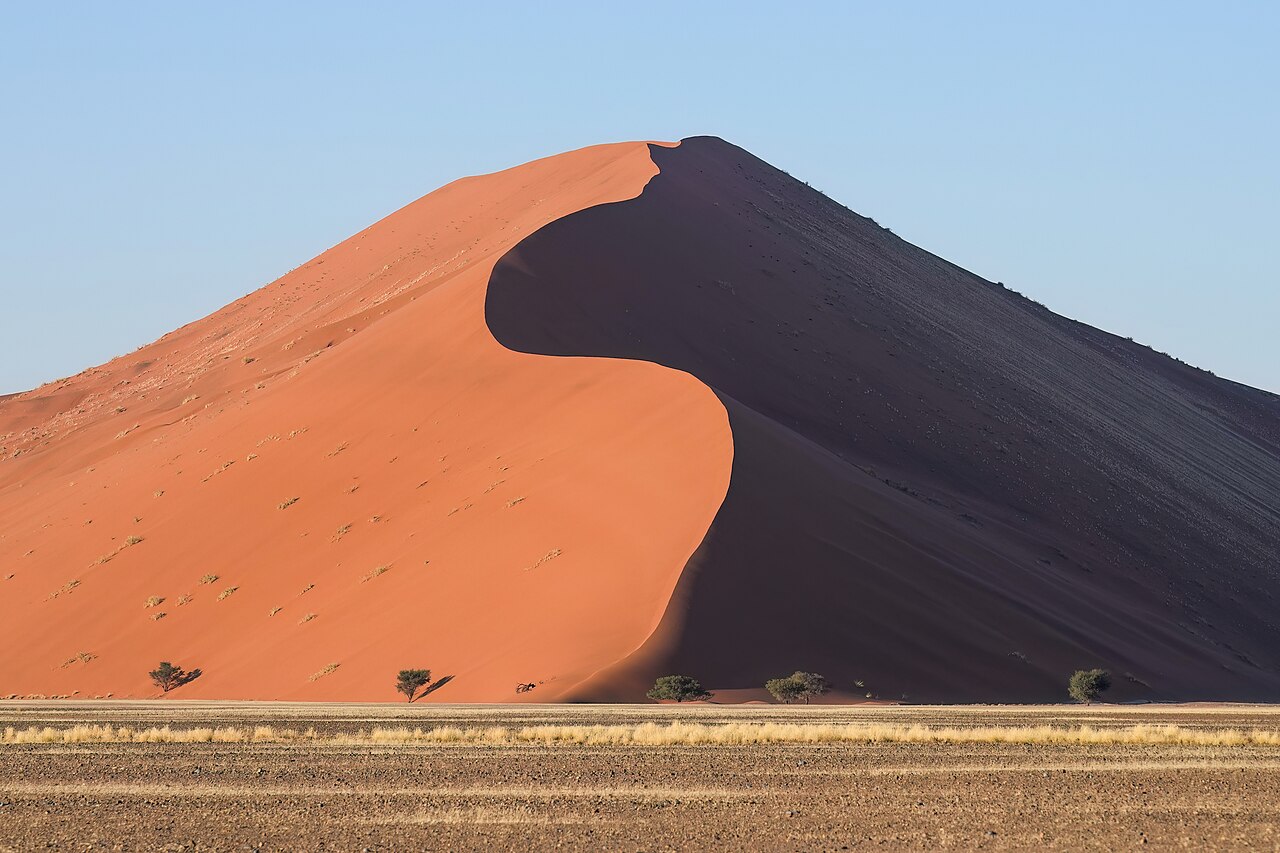
The Sossusvlei dunes rise from the floor of the Namib Desert like nothing else on Earth: apricot-coloured mountains of sand, some topping 300 metres, that glow orange at dawn and burn deep rust at dusk. These are among the tallest and most photographed dunes in the world, and they sit inside Namib-Naukluft Park, the largest game park in Africa at nearly 50,000 square kilometres. The Sossusvlei dunes are not just a scenic backdrop — they are a living geological system, shaped by wind, fog and a river that hasn’t flowed to the sea in living memory.
The Sossusvlei dunes are a field of star dunes and linear dunes in Namibia’s Namib Desert, part of Namib-Naukluft Park roughly 60 km from the Atlantic coast. The highest, Big Daddy, rises about 325 metres from its base, and the surrounding sand is estimated by researchers to be between one and five million years old. The dunes sit at the terminus of the Tsauchab River, whose occasional floods create the white clay pans of Sossusvlei and Deadvlei.
- Where Exactly Are the Sossusvlei Dunes?
- How Were the Sossusvlei Dunes Formed?
- Big Daddy, Big Mama and the Tallest Dunes in the Sossusvlei Dunes Field
- Deadvlei and Sossusvlei: The Pans at the End of the River
- When to Visit the Sossusvlei Dunes
- Wildlife and Life at the Edge of the Sossusvlei Dunes
- People, History and the Modern Namibian Desert
- Practical Guide: Getting There, Staying There and Doing It Well
- Why the Sossusvlei Dunes Matter Beyond the Photograph
Where Exactly Are the Sossusvlei Dunes?
The dunes lie in the south-central Namib, in the Hardap Region of Namibia, about 350 km southwest of Windhoek by road. The gateway settlement is Sesriem, home to the park’s main entrance gate and a small cluster of lodges, campsites and a fuel station. From Sesriem, a paved road runs 60 km into the dune field, ending at a car park where the final 5 km to Sossusvlei itself is a soft-sand track negotiated by 4×4 or by park shuttle.
The name is a hybrid: sossus from the Nama word for “no return” or “dead end,” and vlei from Afrikaans for a shallow marsh or pan. Together, “Sossusvlei” describes the clay pan where the Tsauchab River ends its journey, blocked by dunes before it can reach the sea. The neighbouring pan of Deadvlei — “dead marsh” — is the more famous of the two, famous for its bleached camel-thorn skeletons standing against a wall of red sand.
The nearest town of any size is Sesriem’s service hub; the regional centre is Maltahöhe, roughly 100 km east. The Atlantic coast at Walvis Bay and Swakopmund lies about 300 km northwest, over the Naukluft Mountains and across the gravel plains of the Namib. Most visitors fly into Hosea Kutako International Airport near Windhoek and drive, or take a small aircraft to a nearby airstrip at Sesriem or Solitaire.
How Were the Sossusvlei Dunes Formed?
The sand itself is the first clue. Much of it originated far to the east, in the Orange River basin and the Kalahari, carried to the Atlantic by rivers and then swept north along the coast by the cold Benguela Current. Onshore winds, driven by the same current’s cooling effect, pushed the grains inland over millions of years, piling them into the dune sea that now stretches some 32,000 square kilometres along the Namib coast.
Geologists date the oldest Namib sands to the Miocene, with the dune system in roughly its present form for at least a million years. The red colour comes from iron oxide coatings on the quartz grains — a patina that builds up over long exposure to the air. Younger, paler sands at the coast are still working their way inland, which is why the western dunes near the sea are lighter and the inland Sossusvlei dunes are deeper red.
Star Dunes, Linear Dunes and the Wind That Builds Them
Sossusvlei is unusual because it contains several dune types in one place. The dominant forms are linear dunes — long, parallel ridges aligned with the prevailing southerly and south-westerly winds. Where wind regimes conflict, the sand builds star dunes, with ridges radiating from a central peak. Big Daddy and its neighbour Big Mama are star dunes, which is why they rise so steeply from the valley floor rather than running in a long line.
The prevailing wind at Sossusvlei comes from the southwest, but in winter, easterly winds blow the crests back the other way. This seasonal reversal is what keeps the dunes sharp-edged and mobile. Sand moves at a few metres per year on the crests — slow enough that the landscape looks permanent, fast enough that the shape of a dune shifts measurably over a human lifetime.
Big Daddy, Big Mama and the Tallest Dunes in the Sossusvlei Dunes Field
Big Daddy is the headline act. Measured from the valley floor at Sossusvlei to its crest, it stands about 325 metres, making it one of the tallest dunes in the world. The climb takes most walkers 45 minutes to an hour and a half, depending on fitness and the heat. The reward at the top is a view over the pan below and, on clear mornings, a horizon of dune crests fading into haze.
Big Mama, slightly lower and just to the north, is often climbed first by visitors who want a shorter ascent. Dune 45 — named for its distance in kilometres from Sesriem — is the most accessible of the tall dunes, right beside the paved road, and the standard sunrise stop for tour groups. Its crest is around 170 metres above the surrounding plain.
Elim Dune, closer to the park entrance, offers a gentler climb and a wide view of the dune sea. For travellers with limited time, Elim and Dune 45 deliver the classic Sossusvlei photograph without the effort of Big Daddy. For those who want the full experience, the walk from the 4×4 car park to Big Daddy’s base crosses the vlei itself, often on damp clay after rain.
Deadvlei and Sossusvlei: The Pans at the End of the River
The Tsauchab River rises in the Naukluft Mountains and flows west toward the Atlantic, but it never gets there. About 60 km from the coast, the dune field blocks its path, and the river spreads out into a series of clay pans. In good rain years, water reaches Sossusvlei and briefly fills the pan, attracting flamingos, pelicans and other waterbirds — a startling sight in the middle of a desert.
Deadvlei is the drier, more famous sibling. Roughly 1,000 years ago, the river changed course and cut off the pan from its water supply. The camel-thorn trees that grew there died, but the arid climate preserved them: no moisture means no bacterial decay, and the wood has stood, bleached and blackened, ever since. The pan is reached on foot from the 4×4 parking area, a walk of about 1 km over sand and clay.
Why the Trees in Deadvlei Are Still Standing
The dead trees are estimated to be around 900 years old, though some sources put them at up to 1,000. They survive because the pan is extremely dry, the wood is hard and resinous, and the surrounding dunes block wind-blown sand from burying them completely. The contrast — white clay, black branches, red dunes, blue sky — is why Deadvlei has become one of the most reproduced landscapes in African photography.
Visitors should know that walking on the pan is permitted but the trees themselves are protected; climbing them or breaking branches is prohibited. The pan can be crowded by mid-morning, so the earliest shuttle from the 4×4 car park, or a guided walk, is the best way to see it with some quiet.
When to Visit the Sossusvlei Dunes
Timing matters more here than at most African destinations. The dunes are at their most photogenic in the first hour after sunrise and the last hour before sunset, when low light rakes across the crests and the shadows turn the sand into sculpted ridges. Midday light is flat and the heat is punishing; the park’s gates open at sunrise and close at sunset, and the gate times shift with the season.
| Season | Months | Conditions | Best For |
|---|---|---|---|
| Cool dry season | May–August | Clear skies, cold nights (near freezing), mild days | Hiking, photography, star gazing |
| Warm dry season | September–October | Hot days, strong winds, excellent visibility | Dune climbing, landscape photography |
| Rainy season | November–April | Hot, occasional thunderstorms, rare flooding of the vlei | Green desert, birdlife, dramatic skies |
| Peak visitor period | July–August, December | Busiest lodges, book well ahead | School holidays, European summer travel |
Winter nights at Sesriem can drop below freezing, and the wind at dawn on the dune crests is cold. Summer days regularly exceed 40°C, and the sand surface can be far hotter. The park service advises carrying at least three litres of water per person for a dune climb and starting early.
Wildlife and Life at the Edge of the Sossusvlei Dunes
The dunes look empty, but they are not. The Namib is one of the oldest deserts on Earth, and its species have had millions of years to adapt. The fog that rolls in from the Atlantic most mornings is the key: it delivers moisture to creatures that never see rain. The Namib desert beetle Stenocara gracilipes captures fog on its bumpy back and channels it to its mouth — a mechanism that inspired a fog-harvesting design studied at MIT and elsewhere.
Sidewinder snakes, sand-diving lizards and the translucent Namib web-footed gecko live on and around the dunes. On the gravel plains and in the vlei, oryx, springbok, ostrich and bat-eared fox are regularly seen. The Toktokkie beetle, which knocks on the ground to attract a mate, is a favourite of night walks. Birdlife concentrates around water: Ludwig’s bustard, the dune lark (endemic to the Namib) and, after rain, flamingos at Sossusvlei.
- Dawn: fog and low light; best for dune photography and animal activity
- Mid-morning: heat rises; retreat to shade or the vlei pan
- Late afternoon: second photographic window; cooler climbing
- Night: exceptional stargazing; the Namib is far from light pollution
People, History and the Modern Namibian Desert
The Namib has been inhabited for tens of thousands of years. San hunter-gatherers, ancestors of the Ju/’hoansi and other San groups, left rock art in the region; the Nama, pastoralists who moved south with livestock, gave the desert many of its place names. The name “Namib” itself comes from the Nama word for “vast place.”
German colonial rule from the 1880s brought roads, missions and, infamously, the genocide of the Herero and Nama peoples between 1904 and 1908 — a history Namibia continues to reckon with, and one that shapes how the country presents its heritage today. Namibia gained independence in 1990, and since then tourism has become a pillar of the economy, with community conservancies — a network of locally managed conservation areas — giving rural Namibians a direct stake in wildlife and landscape protection.
Namib-Naukluft Park was proclaimed in 1979, consolidating earlier reserves. It is managed by Namibia Wildlife Resorts and the Ministry of Environment, Forestry and Tourism. The park’s dunes are protected, but they face pressure from off-road driving, litter and the growing number of visitors. The park authority has restricted vehicle access to the soft-sand sections and requires permits for the 4×4 route to Sossusvlei.
Conservation and the Future of the Dune Field
Climate change is a live concern. The Namib’s fog is driven by the Benguela Current, and shifts in ocean temperature could alter fog frequency, with knock-on effects for fog-dependent species. Researchers at the Gobabeb Namib Research Institute, a field station founded in 1962 about 120 km west of Sesriem, have monitored the desert’s ecology for decades and continue to study how the dune system responds to changing conditions.
Tourism revenue, when well managed, funds anti-poaching, road maintenance and research. The main risks are the ones familiar across Africa’s iconic landscapes: too many vehicles in sensitive areas, water use by lodges in a water-scarce region, and the temptation to chase Instagram moments at the expense of the resource. Visitors can help by using licensed guides, staying on marked routes and choosing operators with documented conservation commitments.
Practical Guide: Getting There, Staying There and Doing It Well
The classic route is a self-drive from Windhoek via Rehoboth, Kalkrand and Maltahöhe, or via Solitaire, a tiny settlement with a famous bakery and a wrecked car yard that has become a photo stop in its own right. The drive takes five to six hours on good tar and gravel roads. Alternatively, fly to Sesriem airstrip or take a small plane to a lodge airstrip in the private conservancies bordering the park.
Accommodation ranges from the park’s own campsite at Sesriem — book months ahead — to luxury lodges in the private reserves, many of which run their own guided dune excursions and offer hot-air balloon flights at dawn. Ballooning over the dune sea is one of the most memorable ways to see the Sossusvlei dunes from above, though it is weather-dependent and expensive.
- Permits: Buy at the Sesriem gate or online in advance; the 4×4 shuttle to Sossusvlei and Deadvlei is a separate fee
- Vehicle: A 2WD is fine for the paved road; the final 5 km requires 4×4 or the park shuttle
- Timing: Enter at gate opening; the first hour of light is the whole point
- Water and sun: Three litres per person minimum; hat, sunscreen, closed shoes
- Respect: Do not climb the Deadvlei trees; stay on marked paths; carry out all litter
Why the Sossusvlei Dunes Matter Beyond the Photograph
The Sossusvlei dunes are often reduced to a postcard: red sand, dead trees, blue sky. That image is real, but it undersells what is happening here. This is a working desert system — sand in transit from the Orange River to the interior, fog feeding beetles and geckos, a river that ends in a pan rather than the sea, and a national park that has become a model for community-linked conservation in southern Africa.
Standing on Big Daddy at sunrise, with the shadow of the dune stretching across the valley and the vlei glowing white below, the scale is what stays with you. The Sossusvlei dunes are among the youngest-looking landscapes on a very old continent, and they reward the traveller who arrives early, walks slowly and understands that the sand underfoot has been on the move for longer than any human story.