📅 Last updated: 15.10.2026
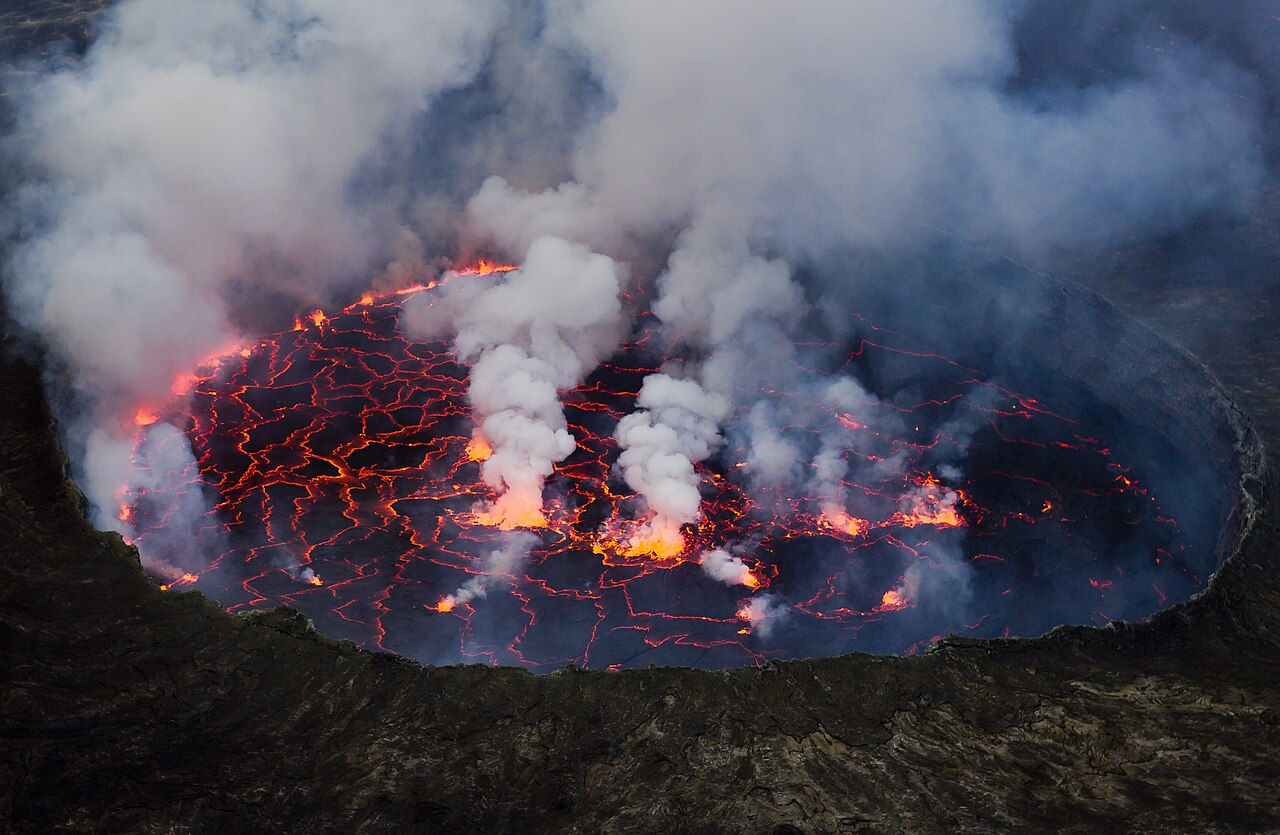
The Nyiragongo volcano hike is one of the most extraordinary experiences on the African continent — a steep climb through rainforest and volcanic rock to the rim of a crater holding the world’s largest active lava lake. Standing above that molten cauldron as night falls, you watch the Earth’s mantle glow and churn a few hundred metres below your boots. Few treks on the planet put you this close to raw, living geology.
Mount Nyiragongo rises to about 3,470 metres in Virunga National Park, eastern Democratic Republic of the Congo, roughly 20 kilometres north of Goma. The hike typically takes four to six hours up and three to four hours down, with a night spent in cabins on the crater rim above a lava lake that can measure hundreds of metres across. Permits are arranged through Virunga National Park and must be booked with a licensed operator in advance.
- Where Is Nyiragongo, and Why Does It Matter?
- What Makes the Nyiragongo Lava Lake Unique?
- Planning the Nyiragongo Volcano Hike: Routes, Permits, and Logistics
- How Hard Is the Nyiragongo Volcano Hike, Really?
- When to Go, and What to Pack
- Key Facts and Timeline: Nyiragongo at a Glance
- Who Guides You, and Who Benefits?
- What You Will Remember
This is not a walk in a manicured alpine park. It is a serious climb in a region of active volcanism, dense forest, and complicated human history. That combination is exactly why the experience stays with people for decades. This guide covers what the trek involves, how to prepare, what it costs, and why Nyiragongo matters far beyond adventure tourism.
Where Is Nyiragongo, and Why Does It Matter?
Nyiragongo sits in the Albertine Rift, the western arm of the East African Rift System, where the African tectonic plate is slowly tearing apart. The volcano is one of eight major peaks in the Virunga Massif, a chain of volcanoes straddling the borders of the Democratic Republic of the Congo, Rwanda, and Uganda. Its neighbours include Nyamuragira, Africa’s most active volcano, and the dormant Mikeno, Karisimbi, and Visoke.
Virunga National Park, established in 1925 as Africa’s first national park, protects around 7,800 square kilometres of forest, savanna, lava plains, and glacier-capped mountains. UNESCO inscribed it as a World Heritage Site in 1979, later listing it as endangered because of poaching, armed conflict, and oil exploration pressure. The park is also home to roughly a third of the world’s remaining mountain gorillas, alongside chimpanzees, okapi, forest elephants, and lions.
Goma, the provincial capital of North Kivu, sits directly south of Nyiragongo on the shore of Lake Kivu. More than a million people live in and around the city, many of them on top of lava flows from previous eruptions. That proximity makes Nyiragongo one of the most closely watched volcanoes on Earth.
What Makes the Nyiragongo Lava Lake Unique?
Nyiragongo is not a gentle, tourist-friendly volcano with occasional smoke. Its lava is among the fastest-flowing in the world. The melt is a low-silica, alkali-rich basalt that stays fluid at high temperatures, so when it erupts it can move downhill at speeds exceeding 60 kilometres per hour. During the catastrophic eruption of 10 January 2002, lava poured through Goma, destroying an estimated 14,000 homes and forcing hundreds of thousands of people to flee, many across the border into Rwanda. Around 250 people died, largely from explosions at petrol stations and asphyxiation.
The lava lake itself is a permanent feature when the volcano is in its usual state. It sits inside a summit crater roughly two kilometres wide, and the lake’s surface has varied from a few hundred metres across to more than a kilometre during high stands. In 2016, a team led by Italian volcanologist Dario Tedesco measured the lake as the largest in recorded history at that point. The glow is visible from Goma on clear nights, a red smudge above the city skyline.
A Volcano That Shaped a City
Goma’s relationship with Nyiragongo is intimate and uneasy. The 2002 flow split the city, burying the airport runway’s edge and cutting the main road. In May 2021, another eruption sent lava toward the eastern districts of Goma, killing at least 32 people and destroying more than 3,000 homes. Scientists from the Goma Volcano Observatory monitor seismic activity, gas emissions, and ground deformation continuously, though the observatory has faced funding and security challenges.
For visitors, this context matters. The Nyiragongo volcano hike is not a theme-park ride. It is a chance to stand on a living feature that has shaped the lives of millions of people and continues to do so.
Planning the Nyiragongo Volcano Hike: Routes, Permits, and Logistics
There is essentially one trekking route to the summit, operated by Virunga National Park. The trail starts at the Kibati Ranger Post, about 20 kilometres north of Goma on the road toward the town of Sake and the park’s southern sector. Trekkers register, meet their ranger guides and porters, and begin the ascent in the morning, usually between 8am and 10am.
Permits are mandatory and cost around US$300 to US$400 per person, depending on the season and operator, with prices set by the park. Bookings are made through Virunga National Park’s official channels or through established tour operators in Goma, Kigali, or Kampala. Demand is high in the dry seasons, so reserving weeks or months ahead is wise. The permit covers the ranger guide, a night in the summit cabins, and basic meals, though many operators bundle transport, accommodation in Goma, and porter fees into a package.
What the Trek Actually Involves
The route covers roughly eight kilometres of horizontal distance and about 1,500 metres of vertical gain. That is a serious day’s work. The first section winds through farmland and then dense montane forest, where you may hear chimpanzees or see turacos and sunbirds. The middle section crosses old lava fields and scrub, exposed to sun and wind. The final push climbs steep, loose volcanic scree and rock steps, often in mist or rain.
Most hikers take four to six hours to reach the rim. Fit walkers can do it in under four; those who struggle with altitude or heat may take seven. The descent the following morning is faster, usually three to four hours, but it is hard on the knees because of the loose footing. Trekking poles help enormously.
Sleeping on the Rim
At the top, the park maintains a cluster of simple wooden cabins and a ranger shelter on the crater rim. You sleep in a bunk with a mattress and blankets, though you should bring a warm sleeping bag or liner because temperatures at 3,470 metres can drop close to freezing. The reward is the view: from the cabin door, the lava lake glows orange and red, pulsing and cracking as gas bubbles burst on the surface. At night, the effect is hypnotic. Most people barely sleep, and few regret it.
How Hard Is the Nyiragongo Volcano Hike, Really?
Honest answer: harder than most people expect, but achievable for anyone with reasonable fitness and determination. The altitude is the main challenge. Goma sits at about 1,500 metres, and the summit is at 3,470 metres, so you gain nearly two kilometres of elevation in a single day. Acute mountain sickness affects some trekkers, particularly those who fly in from sea level and start the next morning.
Heat and humidity in the forest section sap energy. Rain can turn the scree into a slippery mess. And the mental strain of walking through a region with a history of conflict adds a layer that no fitness test captures. That said, thousands of people complete the trek each year, including older walkers and teenagers. Porters will carry your bag for a modest fee, and hiring one is both practical and a direct boost to local livelihoods.
- Fitness baseline: If you can hike uphill for five hours with a daypack, you can do this.
- Altitude preparation: Spend a night or two in Goma or at higher elevation in Rwanda before starting.
- Pacing: Start slow, drink water steadily, and take the ranger’s breaks seriously.
When to Go, and What to Pack
The dry seasons — roughly June to September and December to February — offer the clearest skies and the best views of the lava lake. The rainy seasons bring mud, cloud, and a higher chance the crater will be obscured, though the lake is often visible through gaps. Because Nyiragongo sits close to the equator, temperatures at the base are warm year-round, while the summit is cold at night.
Security conditions in eastern DRC fluctuate. Virunga National Park has suspended tourism at various points, including after the 2021 eruption and during periods of armed group activity. Always check the park’s official advisories and your government’s travel guidance before booking. Most treks are organised with armed ranger escorts, and the park controls access tightly.
Essential Gear Checklist
- Sturdy hiking boots with ankle support and broken-in soles.
- Layers: moisture-wicking base, insulating mid-layer, windproof and waterproof shell.
- Warm hat, gloves, and a fleece or down jacket for the rim.
- Headlamp with spare batteries for night viewing of the lake.
- At least three litres of water, high-energy snacks, and water purification tablets.
- Sun protection: hat, sunglasses, and high-SPF sunscreen.
- Small first-aid kit, personal medication, and cash for porters and tips.
Key Facts and Timeline: Nyiragongo at a Glance
| Date or Figure | Event or Detail |
|---|---|
| 1925 | Virunga National Park established as Africa’s first national park. |
| 1977 | Major eruption; lava flows kill several hundred people near Goma. |
| 10 January 2002 | Eruption destroys around 14,000 homes in Goma; roughly 250 deaths. |
| 2016 | Researchers record the lava lake at its largest size in documented history. |
| 22 May 2021 | Eruption sends lava toward eastern Goma; at least 32 deaths, 3,000+ homes lost. |
| Summit elevation | Approximately 3,470 metres (11,385 feet). |
| Typical permit cost | About US$300–US$400 per person, booked through the park. |
Who Guides You, and Who Benefits?
The trek is staffed almost entirely by Congolese rangers and porters from communities around the park. Virunga National Park employs hundreds of rangers, many of whom have lost colleagues to poaching and armed groups — more than 200 rangers have died protecting the park since the 1990s. Tourism revenue, when it flows, funds ranger salaries, community projects, and conservation work. Hiring a porter is not charity; it is part of the economic logic that makes protecting the volcano and its forests viable.
The park also supports hydropower projects, fisheries, and agricultural cooperatives around its boundary, part of a broader effort to show that a living volcano and a living park can coexist with human development. That story is as much a part of the Nyiragongo volcano hike as the lava itself.
What You Will Remember
The moments that stay with people are rarely the summit photo. They are the sound of the lake — a low, continuous roar like a distant ocean — and the way the crust on the surface shifts, cracks, and reveals fresh red beneath. They are the cold wind on the rim at 3am and the shared silence of a dozen strangers watching the planet breathe. They are the descent through forest the next morning, when the volcano is hidden again behind cloud and the world feels ordinary once more.
Nyiragongo is not a safe, sanitised attraction, and it should not be sold as one. It is a real volcano above a real city, monitored by real scientists, climbed with real risk. That is precisely what makes the Nyiragongo volcano hike one of Africa’s defining adventures — a rare chance to meet the Earth’s interior on its own terms, in a landscape shaped by Congolese history, resilience, and the stubborn beauty of the Albertine Rift.