📅 Last updated: 18.11.2026
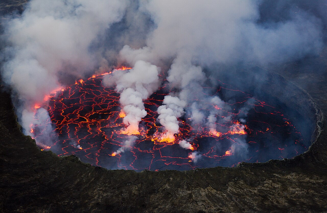
Every year, a few thousand travellers make the pilgrimage to eastern Democratic Republic of Congo for the Nyiragongo volcano hike, a trek that leads to the world’s largest active lava lake and one of the planet’s most electrifying natural spectacles. Standing on the crater rim at 3,470 metres, watching molten rock churn in the abyss below, is an experience that few volcanoes on Earth can match. The mountain rises directly above the city of Goma and Lake Kivu, and its fiery glow has shaped the history, economy, and folklore of the region for centuries.
The Nyiragongo volcano hike is a guided overnight trek from Kibati ranger post (about 1,990 m) to the crater rim at 3,470 m, typically taking 4–6 hours up and 3–4 hours down. Hikers spend a night in wooden shelters at the summit, where they look down into the world’s largest active lava lake. The trek is organised by Virunga National Park and requires permits, armed ranger escorts, and advance booking.
- Why Is Nyiragongo's Lava Lake Considered Africa's Most Dangerous?
- Planning the Nyiragongo Volcano Hike: Permits, Costs, and Logistics
- What Happens on the Trail: A Step-by-Step Account of the Hike
- Nyiragongo Volcano Hike Safety: What Rangers and Scientists Monitor
- Who Are the People Behind the Nyiragongo Volcano Hike?
- How Does Nyiragongo Compare to Other Volcanic Treks in Africa?
- The Future of the Nyiragongo Volcano Hike and Virunga Conservation
- A Lasting Perspective on Africa's Most Daring Trek
Why Is Nyiragongo’s Lava Lake Considered Africa’s Most Dangerous?
Nyiragongo is not the most explosive volcano in the world, but it may be the most feared. Its lava is an unusual alkali-rich nephelinite that flows with astonishing speed. During the catastrophic eruption of 10 January 2002, lava poured down the southern flank at up to 60 kilometres per hour, reaching the northern edge of Goma within minutes and eventually splitting the city. Around 400,000 people fled, dozens died, and the main street was cut in two by a river of solidified basalt that remains visible today.
The danger is structural. Unlike volcanoes with thick, sticky magma that build pressure and erupt violently, Nyiragongo’s fluid lava drains rapidly when the crater’s internal fractures open. The lava lake sits atop a persistent conduit connected to the East African Rift, and the mountain’s slopes are densely populated. Goma, with roughly two million residents, sits barely 18 kilometres from the summit. The 1977 eruption killed more than 600 people in under an hour, and the 2021 eruption sent lava toward the airport and Buhene village, killing over 30 people and displacing thousands.
The Science Beneath the Surface
Nyiragongo sits within the Albertine Rift, the western branch of the East African Rift System, where the African plate is slowly splitting. The Goma Volcanological Observatory (OVG) monitors seismic activity, ground deformation, and gas emissions, often with limited resources. Researchers from institutions including the Royal Museum for Central Africa in Tervuren, Belgium, and the University of Cambridge have studied the lake’s convection cycles, which can rise and fall dramatically over days. In 2016 and again in 2020, the lake refilled to levels not seen since before 2002, a sign that pressure was rebuilding.
Planning the Nyiragongo Volcano Hike: Permits, Costs, and Logistics
The trek is managed exclusively by Virunga National Park, Africa’s oldest national park, established in 1925. Permits are not cheap and are not casual: the park charges around $300–$400 per person for the overnight hike, which includes ranger guides, porters, shelter at the summit, and basic meals. Prices have fluctuated with security conditions and park funding. Bookings are made through the official Virunga website or authorised tour operators in Goma, and demand often exceeds availability during the dry seasons.
Getting to Goma is itself part of the adventure. Most international visitors fly into Kigali, Rwanda, then cross the land border at Gisenyi–Goma, a journey of about three hours by road. Direct flights to Goma International Airport exist from Kinshasa and a few regional carriers, but schedules are unreliable. Visas for DRC can be obtained online or on arrival in some cases, but travellers should confirm current rules with the Congolese embassy.
- Best months: June to August and December to February are driest, though rain can fall any time.
- Fitness level: Moderate to demanding; the trail is steep and rocky, with altitude gain of about 1,500 metres.
- What to pack: Layered clothing, waterproof shell, headlamp, gloves, warm hat, 3 litres of water, high-energy snacks, and sturdy hiking boots.
- Security: Check your government’s travel advisory and the park’s current status; ranger escorts are mandatory.
What Happens on the Trail: A Step-by-Step Account of the Hike
The Nyiragongo volcano hike begins at Kibati ranger post, around 1,990 metres, where hikers register, meet their ranger team, and hire porters. The first hour winds through montane forest and old lava flows, past the ruins of a 2002 eruption channel. The vegetation thins as the trail climbs, giving way to heathland and then bare volcanic rock. The path is well marked but relentless, with switchbacks over loose scoria that demand steady footing.
Acclimatisation and Pacing
Altitude sickness is a real risk. The summit sits at 3,470 metres, and hikers who arrive from sea level the same day often feel breathless. The park recommends a slow, steady pace, and rangers are trained to monitor symptoms. Most groups take four to six hours to reach the rim, with rest stops every 45 minutes. Porters, many from villages around Kibati and Rugari, carry supplies and can be hired for around $20–$30, a vital source of income for local families.
The Crater Rim at Night
Arriving at the rim is a moment of pure awe. The lava lake, sometimes over 200 metres wide, glows orange and red, with fountains spitting molten rock into the air. At night, the lake’s convection cells shift like a slow, incandescent tide. The park has built simple wooden shelters with benches and basic bedding, and hikers eat a hot meal while watching the spectacle. Temperatures at the summit can drop to near freezing, and wind is constant. Sleep is optional; most people sit up, cameras ready, listening to the deep rumble of the mountain.
Nyiragongo Volcano Hike Safety: What Rangers and Scientists Monitor
The hike is only permitted when the park and the Goma Volcanological Observatory judge conditions safe. Rangers carry radios and maintain contact with OVG throughout the night. The park closes the trail when seismic activity, gas emissions, or lake levels suggest elevated risk. In 2021, the eruption occurred without a full evacuation warning, exposing gaps in monitoring. Since then, international partners have supported OVG with new instruments and training, and the park has tightened its safety protocols.
| Eruption / Event | Year | Key Impact |
|---|---|---|
| Major eruption | 1977 | Over 600 deaths; lava lake drained rapidly |
| Catastrophic eruption | 2002 | ~400,000 displaced; Goma split by lava flow |
| Lake refill | 2016 | Lava lake returned to pre-2002 levels |
| Eruption | 2021 | 30+ deaths; lava reached Goma outskirts |
| Park reopening | 2022–2023 | Hikes resumed under revised safety protocols |
Who Are the People Behind the Nyiragongo Volcano Hike?
The trek is a livelihood for hundreds of Congolese. Rangers, many from communities around Rumangabo and Kibati, are trained by Virunga’s ranger force, an institution that has lost more than 200 rangers to poaching and armed conflict over the decades. Porters, cooks, and guides earn wages that support families in a region where formal employment is scarce. The park’s tourism revenue, when it flows, funds conservation, patrols, and community projects such as schools and health clinics.
The Nyiragongo volcano hike also carries cultural weight. Local communities have long regarded the mountain with reverence and fear; oral traditions describe the fire as a living force. In recent years, Congolese musicians and artists have drawn on the volcano’s imagery, and Goma’s vibrant cultural scene, from rumba to contemporary art, reflects a city that lives with risk and creativity in equal measure.
How Does Nyiragongo Compare to Other Volcanic Treks in Africa?
Africa offers several volcanic adventures, but Nyiragongo is singular. Mount Kilimanjaro in Tanzania is higher (5,895 m) but dormant; its trek is about endurance, not fire. Mount Cameroon is active but rarely offers a lava lake view. Nyamuragira, Nyiragongo’s neighbour in Virunga, is more explosive but lacks a permanent lake. Erta Ale in Ethiopia’s Danakil Depression has a lava lake, but access is more remote and infrastructure thinner. Nyiragongo’s combination of accessibility from Goma, organised ranger support, and a summit shelter makes it the most feasible lava-lake trek on the continent.
The Future of the Nyiragongo Volcano Hike and Virunga Conservation
Virunga National Park faces persistent challenges: armed groups, illegal charcoal trade, oil exploration pressures, and the 2021 eruption’s aftermath. Yet the park remains a beacon of Congolese conservation, home to mountain gorillas, okapis, and extraordinary biodiversity. Tourism, when it functions, provides a powerful counterweight to those pressures. The Nyiragongo volcano hike is not just an adrenaline pursuit; it is a direct contribution to the protection of one of Africa’s most important landscapes.
Travellers who make the trek should do so with respect for the mountain, the rangers, and the communities who live in its shadow. The experience is raw, humbling, and unforgettable. Standing above a churning lava lake, with the lights of Goma flickering below and the stars above, you understand why Nyiragongo holds such a grip on the imagination.
A Lasting Perspective on Africa’s Most Daring Trek
The Nyiragongo volcano hike is a rare convergence of geology, human resilience, and wild beauty. It is a reminder that Africa’s landscapes are not passive backdrops but active, living forces that shape the lives of millions. For those who make the climb, the reward is a night spent at the edge of the Earth’s inner fire, a memory that stays long after the descent. The mountain will continue to rumble and reshape itself; the privilege is to witness it, safely and respectfully, with the people who know it best.