📅 Last updated: 19.09.2026
Lake Turkana, the vast jade-green expanse cradled in the Great Rift Valley of northern Kenya, is unlike any other body of water on Earth. Stretching roughly 290 kilometres from north to south and covering about 6,405 square kilometres, it is the world’s largest permanent desert lake and the fourth-largest lake in Africa by volume. Its waters shimmer an improbable turquoise against a backdrop of volcanic rock, black lava flows, and ochre sand — a colour so striking that early European explorers named it the Jade Sea. But Turkana is far more than a geological curiosity. It is a cradle of human origins, the heartland of the Turkana, El Molo, Samburu, and other peoples, and a living laboratory for understanding how climate, water, and humanity intersect in one of the most arid places on the planet.
- Where the Jade Sea Lies: Geography and Formation
- Lake Turkana and the Cradle of Humankind
- The Peoples of the Lake Turkana Shores
- The Omo River and the Politics of Water
- Wildlife and Landscapes Around Lake Turkana
- Visiting Lake Turkana: A Journey to the Edge of the Map
- Why Lake Turkana Matters to the World
- A Lake That Demands Our Attention
Where the Jade Sea Lies: Geography and Formation
Lake Turkana sits at the northernmost tip of Kenya’s Rift Valley, with its northern shore crossing into Ethiopia. The lake lies at an elevation of about 360 metres above sea level, in a closed basin with no outlet to the sea. The town of Lodwar, the administrative centre of Turkana County, lies to the west, while the remote settlement of Ileret sits near the Ethiopian border to the north. To the east rise the volcanic hills of the Chalbi Desert and Mount Kulal, a 2,285-metre massif that dominates the eastern skyline.
The lake owes its existence to the Omo River, which rises in the Ethiopian highlands and supplies more than 90 percent of its water. The Turkwel and Kerio rivers, which flow from the Kenyan highlands to the west, contribute the remainder — though their flows are highly seasonal and increasingly erratic. Because the lake has no outlet, water leaves only through evaporation, which in this desert environment can exceed two metres per year. That evaporation concentrates dissolved salts and minerals, making Turkana’s waters alkaline and slightly saline — a chemistry that shapes everything from the lake’s fish species to the colour of its water.
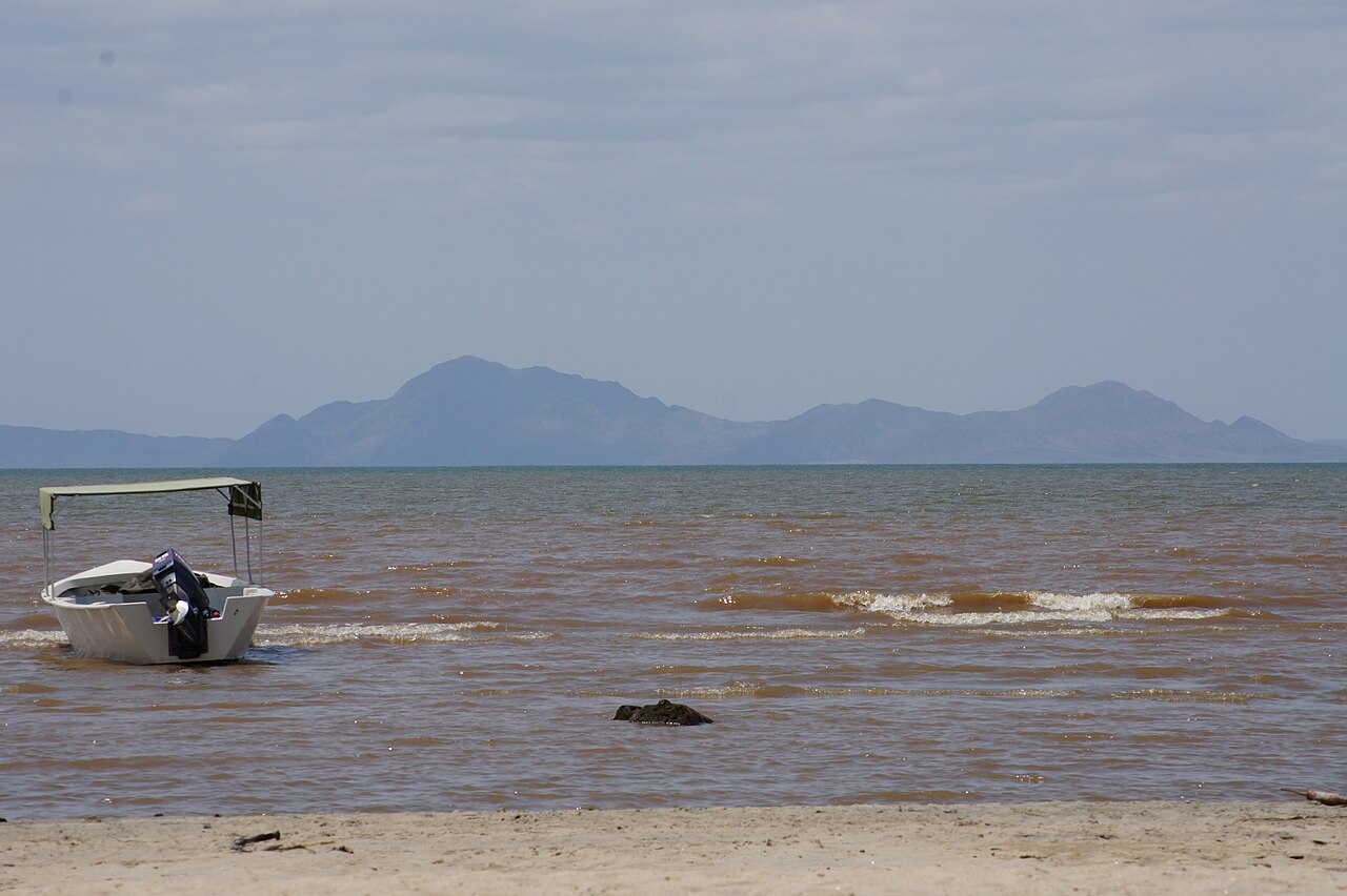
The lake’s distinctive jade hue comes from a combination of factors: suspended sediment carried by the Omo, blooms of microscopic algae, and the way light interacts with the lake’s shallow, mineral-rich waters. The colour shifts throughout the day and season, from pale green at dawn to deep turquoise under the midday sun. It is not a trick of the camera; travellers who have crossed the Chalbi Desert and crested the final ridge describe the moment the lake appears as almost hallucinatory.
Three Names, One Lake
Turkana has carried several names through history. The Turkana people call it Namakat, while the Samburu know it as Basso narok — “the black lake.” Austrian explorer Count Sámuel Teleki was the first European to see it in 1888, and he named it Lake Rudolf after Crown Prince Rudolf of Austria. That name persisted through the British colonial period until 1975, when the Kenyan government renamed it Lake Turkana to honour the Turkana people who have lived along its shores for centuries.
Lake Turkana and the Cradle of Humankind
No account of Lake Turkana can ignore its extraordinary place in the story of human evolution. The lake’s shores and the surrounding badlands of the Koobi Fora formation, on the eastern side of the lake, have yielded some of the most important fossil discoveries in the history of palaeoanthropology. The region is now part of the UNESCO World Heritage-listed Lake Turkana National Parks, inscribed in 1997 and extended in 2001.
The discoveries began in earnest in 1968, when a team led by Kenyan palaeontologist Richard Leakey and his colleagues began systematic excavations at Koobi Fora. In 1972, they unearthed a skull designated KNM-ER 1470, roughly 1.9 million years old, which forced scientists to rethink the timeline of early Homo. In 1984, Kamoya Kimeu — a Kenyan fossil hunter whose instincts became legendary — spotted a fragment of a hominin skull on the western shore near Nariokotome. That find became Turkana Boy, a nearly complete Homo erectus skeleton dating to about 1.6 million years ago, one of the most complete early human skeletons ever discovered.
These discoveries matter because they anchor East Africa — and specifically the Turkana basin — as the region where much of human evolution unfolded. The lake’s sediments, laid down over millions of years, preserve a remarkable record of changing environments, from lush woodlands to open grasslands, that shaped how our ancestors lived, moved, and adapted.
“The Turkana basin is not just a place of fossils. It is a library of our origins, written in sediment and stone.”
A Timeline of Discovery
| Year | Discovery | Significance |
|---|---|---|
| 1888 | Count Teleki becomes first European to see the lake | Names it Lake Rudolf |
| 1968 | Richard Leakey’s team begins work at Koobi Fora | Opens modern palaeoanthropological research in the basin |
| 1972 | Skull KNM-ER 1470 unearthed | Reshapes understanding of early Homo |
| 1984 | Turkana Boy discovered by Kamoya Kimeu | Nearly complete Homo erectus skeleton, ~1.6 million years old |
| 1997 | Lake Turkana National Parks inscribed as UNESCO World Heritage | Global recognition of the basin’s scientific value |
The Peoples of the Lake Turkana Shores
Lake Turkana is not an empty landscape. It is home to communities whose cultures, livelihoods, and identities are inseparable from the water. The Turkana people, after whom the lake is named, are the largest group in the region — pastoralists who herd goats, sheep, cattle, and camels across the arid plains. Their society is organised around clans and age-sets, and their knowledge of the lake’s moods and the desert’s rhythms is deep and practical.
The El Molo, a small fishing community on the lake’s eastern shore near Loiyangalani, are among Kenya’s smallest ethnic groups, numbering only a few thousand. They have fished Turkana’s waters for generations, using harpoons and nets, and their language and traditions are considered endangered. The Samburu, related to the Maasai, live to the south and east, while the Gabbra and Rendille peoples inhabit the surrounding rangelands. Further north, across the Ethiopian border, the Daasanach and other groups also depend on the lake and the Omo River.
These communities are not relics of an untouched past. They are modern Kenyans navigating mobile phones, county politics, and changing markets while maintaining traditions that stretch back centuries. Lodwar has grown into a bustling town with hospitals, schools, and a university campus. Loiyangalani hosts an annual cultural festival that draws visitors from across Kenya and beyond, celebrating Turkana, El Molo, Samburu, and other cultures through music, dance, and crafts.
Fishing and Livelihoods
Fishing is central to life on the lake. Turkana’s waters support species including Nile perch, tilapia, and the endemic Alestes and Hydrocynus — though the lake’s fish fauna is relatively poor in species compared to other African Great Lakes, a consequence of its isolation and harsh chemistry. The Nile perch, introduced in the mid-twentieth century, became a major commercial species, and fishing camps dot the shoreline. Yet the fishery is under pressure from overfishing, changing water levels, and the broader climate stresses affecting the region.
- Turkana — pastoralists and increasingly fishers, the largest group around the lake.
- El Molo — Kenya’s smallest ethnic group, traditionally fishing people of the eastern shore.
- Samburu — pastoralists of the south and east, known for their beadwork and cattle culture.
- Gabbra and Rendille — camel-herding peoples of the surrounding rangelands.
- Daasanach — communities along the Omo River and northern lake in Ethiopia.
The Omo River and the Politics of Water
Lake Turkana’s fate is tied directly to the Omo River. For decades, the Ethiopian government has pursued large-scale hydropower and irrigation development in the Omo basin, most notably the Gilgel Gibe III dam, which began generating electricity in 2015. The dam regulates the Omo’s flow, reducing the seasonal floods that once replenished the lake’s fisheries and supported flood-recession agriculture along the river’s banks.
Scientists and environmental organisations have warned that reduced flows could lower the lake’s level, increase salinity, and damage the delicate balance that sustains fish, wildlife, and people. Kenya has raised concerns through diplomatic channels and at the African Union, while researchers continue to monitor the lake’s hydrology. The debate is not simply about dams; it is about how two neighbouring countries share a transboundary resource in a region where water is life.
At the same time, Turkana County has seen significant oil exploration. Tullow Oil discovered commercial crude oil reserves in the Lokichar basin in 2012, raising hopes of revenue and development — alongside fears about environmental impact and the risk of conflict over land and water. The proposed Lamu Port-South Sudan-Ethiopia Transport (LAPSSET) corridor, with a pipeline from Turkana to the coast, is one of Kenya’s most ambitious infrastructure projects. Whether it delivers prosperity or disruption remains an open question.
Climate Pressure on the Jade Sea
The broader climate picture is sobering. The Horn of Africa has experienced severe droughts in recent decades, including a devastating multi-year drought from 2020 to 2023 that pushed millions into food insecurity. For Turkana’s pastoralists, drought means livestock die, grazing disappears, and families migrate. For fishers, it means falling water levels and uncertain catches. The lake itself is a barometer of these changes — its shoreline shifts, its chemistry alters, and the communities around it adapt as they always have, though now under unprecedented strain.
Wildlife and Landscapes Around Lake Turkana
Despite its harsh setting, the Lake Turkana region supports remarkable biodiversity. The lake is home to the world’s largest population of Nile crocodiles, with estimates running into the tens of thousands. Hippos are common, and the shoreline and islands host a variety of birdlife, including flamingos, pelicans, and migratory species that use the lake as a staging post. Central Island National Park, with its active volcanic craters and crocodile breeding grounds, and South Island National Park are both part of the UNESCO World Heritage site.
The surrounding landscapes are equally dramatic. The Chalbi Desert, a salt pan east of the lake, is one of Kenya’s most otherworldly environments. Mount Kulal, a forested volcanic massif, rises from the desert like an island. The Suguta Valley, south of the lake, is a remote, almost inaccessible rift valley floor with its own string of small lakes. And the volcanic formations around the lake — including the Barrier, a volcanic complex that separates Turkana from the Suguta Valley — tell the story of the tectonic forces that created this whole region.
On the lake’s eastern side, Sibiloi National Park protects fossil sites, petrified forests, and wildlife including Grevy’s zebras, oryx, and gazelles. The park is named after Mount Sibiloi, and its combination of palaeontological and ecological significance is rare anywhere in the world.
- Central Island National Park — volcanic craters, crocodile breeding grounds.
- South Island National Park — breeding site for crocodiles and birds.
- Sibiloi National Park — fossil beds, petrified wood, desert wildlife.
- Mount Kulal — forested massif, important for water catchment and biodiversity.
- Chalbi Desert — vast salt pan, dramatic scenery, cultural significance.
Visiting Lake Turkana: A Journey to the Edge of the Map
Reaching Lake Turkana is an adventure in itself. Most travellers fly into Lodwar from Nairobi, a roughly two-hour flight, or undertake the long overland route from Maralal through the arid north — a journey of several days across some of Kenya’s most remote terrain. The roads are rough, the heat is intense, and services are sparse. That is precisely what makes the experience so memorable.
Loiyangalani, on the southeastern shore, is the main base for visitors. It has simple lodges, a campsite, and access to the lake’s beaches. From there, boats can be arranged to Central Island and South Island. The annual Loiyangalani Cultural Festival, usually held in August, is a highlight for those interested in the region’s living cultures. Further north, the town of Ileret and the Koobi Fora research station offer a glimpse into the scientific work that has made the lake famous.
Practical Considerations
Visitors should be prepared for extreme heat, limited infrastructure, and long distances. Travel is best in the cooler months from June to September, though the lake is visitable year-round. Respect for local communities is essential: ask before photographing people, support local guides and businesses, and remember that this is a living homeland, not a theme park. Security conditions should be checked before travel, as the region borders South Sudan and Ethiopia and has experienced sporadic insecurity.
Why Lake Turkana Matters to the World
Lake Turkana is many things at once. It is a geological marvel, a scientific treasure, a cultural heartland, and an environmental frontline. Its fossils have rewritten the story of human origins. Its waters sustain peoples whose traditions stretch back centuries. Its challenges — climate change, dams, oil, and water politics — are among the most pressing issues facing the continent.
For the African diaspora and for anyone who cares about the continent’s future, Turkana offers a powerful reminder: Africa’s heritage and its modernity are not opposites. The same basin that produced Turkana Boy now hosts research stations, county governments, and community-led conservation efforts. The same lake that inspired the name Jade Sea now sits at the centre of debates about sustainable development and transboundary cooperation.
To stand on Turkana’s shore is to stand at the intersection of deep time and urgent present. The lake has witnessed the rise of our species and the passage of empires. Whether it continues to thrive depends on decisions being made now — by governments, by communities, and by a world that too often overlooks this extraordinary place.
A Lake That Demands Our Attention
Lake Turkana is not a postcard. It is a living, contested, and irreplaceable place. Its jade waters reflect not just the desert sun but the choices we make about water, energy, and heritage. The Turkana people have a saying that the lake is their mother — she feeds them, she shelters them, and she demands respect. As the pressures on the Jade Sea mount, that wisdom deserves a global audience. To know Lake Turkana is to understand something essential about Africa: its deep past, its present struggles, and its enduring capacity for resilience and renewal.