📅 Last updated: 14.09.2026
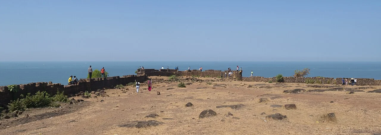
Chapora Fort Goa sits on a wind-scoured headland above the mouth of the Chapora River, its laterite ramparts glowing rust-red against the Arabian Sea. From its grassy ramparts you can watch fishing trawlers chug out of the estuary while backpackers below on Chapora Beach string up hammocks for the afternoon. The fort is a ruin in the best sense — roofless, overgrown, still standing — and it carries nearly five centuries of Goan history in its crumbling walls.
- Where Is Chapora Fort Goa? Geography and Setting
- The Laterite Story: Why the Fort Is Red
- History of Chapora Fort Goa: From Bahadur to the Portuguese
- What You Actually See Inside the Walls
- Chapora Fort Goa Today: Sunset, Cinema, and Crowds
- Beyond the Fort: Chapora Village and the Wider Coast
- Conservation Challenges and the Future of the Fort
- Why Chapora Fort Still Matters
Most visitors arrive for the sunset and the famous view over Vagator’s red cliffs. That is reason enough. But the story of this fort is far richer than its Instagram reputation suggests: it is a story of Portuguese strategy, Maratha defiance, Hindu and Muslim layers beneath Catholic stone, and a laterite geology that shaped everything built here. Here is the full picture.
Where Is Chapora Fort Goa? Geography and Setting
Chapora Fort stands in the village of Chapora, in Bardez taluka, North Goa district, roughly 10 kilometres north of Anjuna and about 22 kilometres from Panaji, the state capital. It occupies the southern bank of the Chapora River where the river meets the sea, on a headland that rises about 40 metres above the water. The fort faces north across the river mouth toward Morjim and Ashwem; to its south and east lie Anjuna and Vagator.
The position is not accidental. The Chapora River was, and remains, a navigable inlet used by fishing boats and small traders. Whoever controlled the headland could observe every vessel entering or leaving the estuary, and could threaten shipping along the coast. The site also overlooks a natural anchorage, which is why the Portuguese, and before them earlier powers, saw value in fortifying it.
The view from the top is the reason the fort has become one of North Goa’s most visited landmarks. On a clear evening you can see:
- The Chapora River curling inland toward the village of Siolim
- The broad curve of Chapora Beach and the smaller Vagator and Ozran beaches to the south
- Morjim Beach and its sandbar across the river to the north
- The Arabian Sea stretching unbroken to the horizon
- The red laterite cliffs of Vagator, one of Goa’s most photographed coastlines
Getting there is part of the experience. From the village, a steep paved path climbs past a small football ground and a chapel, then narrows into a rocky trail up the headland. The walk takes 15 to 20 minutes at a relaxed pace. Wear shoes with grip — the final stretch is uneven, and the laterite gets slick after rain.
The Laterite Story: Why the Fort Is Red
Chapora Fort is built almost entirely of laterite, and understanding that material explains both the fort’s durability and its decay. Laterite is a soil and rock type formed in the tropics when heavy monsoon rain leaches silica out of the ground and concentrates iron and aluminium oxides. The result is a porous, rusty-red stone that hardens when exposed to air but softens when freshly cut — which is why it was traditionally quarried and shaped while still moist.
Goa’s laterite has been used for construction for well over a thousand years. The same stone built the temples of Kadamba-era Goa, the walls of Old Goa’s churches, and countless village houses across the state. It is cheap, locally abundant, and workable with simple tools. It also has a weakness: laterite is porous, so it absorbs water, and over centuries of monsoons it erodes, cracks, and crumbles.
That is exactly what has happened at Chapora. The fort’s walls are visibly eroded, with deep fissures running through the ramparts and sections of masonry slumped into mounds of red earth. What looks like neglect is actually geology and time doing their work. Conservation here is difficult precisely because laterite is so reactive to the climate — a problem shared by heritage sites across the Konkan coast.
There is a modern twist. Laterite is still quarried in Goa today, and its extraction has become an environmental flashpoint, linked to hill-cutting, loss of green cover, and groundwater problems. The fort, in a sense, is a monument to a material that is both Goa’s signature building stone and one of its contested resources.
History of Chapora Fort Goa: From Bahadur to the Portuguese
The site’s recorded history begins before the Portuguese. In the sixteenth century, the area around Chapora was under the control of the Adil Shahi Sultanate of Bijapur, which dominated much of the Konkan coast. The Adil Shahis built a fort here, and the Portuguese chroniclers referred to it as Porto de Dabul or by the name of the local ruler they associated with it — Bahadur, a title meaning “brave” or “warrior.” Hence the fort’s older name, Fort Bahadur or Fortaleza de Bahadur, sometimes rendered in Portuguese records as Fortaleza do Chapora.
The Portuguese took the site in 1717, during a period when they were strengthening their northern frontier against the Marathas. The Maratha Empire under the Peshwas was expanding aggressively into the Konkan, and the Portuguese, whose capital was Old Goa further south, needed to defend the approaches to their territory. Chapora’s position at a river mouth made it a natural guard post on the northern border of Portuguese Goa.
But Portuguese control was not secure. In 1739, during the Maratha invasion of Goa led by the Peshwa’s forces, the Portuguese lost Chapora and several other northern forts. The Marathas held the region briefly before the Portuguese regained it in 1741 under a treaty with the Maratha confederacy. It was after this recovery that the Portuguese rebuilt and expanded the fort substantially, giving it much of the form we see today.
The fort’s military life was relatively short. By the nineteenth century, with the Maratha threat gone and Portuguese power in decline, Chapora lost its strategic value. It was abandoned as a garrison in 1892, and from then on the laterite walls were left to the monsoon and the cashew trees.
Key dates at a glance
| Period | Event | Who Controlled the Site |
|---|---|---|
| 16th century | Fortified headland above the Chapora River | Adil Shahi Sultanate of Bijapur |
| 1717 | Portuguese capture and garrison the fort | Portuguese Estado da Índia |
| 1739 | Maratha invasion of Goa; Portuguese lose the fort | Maratha Empire |
| 1741 | Treaty restores the fort to Portugal; major rebuild follows | Portuguese Estado da Índia |
| 1892 | Fort abandoned as a military post | Unoccupied ruin |
| 1961 | Goa becomes part of India; fort comes under Indian administration | Republic of India |
What You Actually See Inside the Walls
Chapora Fort is not a palace fort or a showpiece like Agra Fort. It is a military outpost, and its architecture reflects that: functional, compact, and built for observation and defence rather than comfort. What survives is the outer circuit of laterite walls, punctuated by bastions, with a large open interior now covered in grass and scrub.
As you walk the perimeter, look for these features:
- Bastions and gun emplacements — the projecting corners of the wall were designed for cannon and for enfilading fire along the ramparts. Several still show the platforms where artillery once stood.
- The main gateway — a simple arched entrance on the landward side, the fort’s only practical approach.
- The cisterns — underground water storage tanks cut into the laterite, essential for a garrison that could be cut off during a siege. Some are now dry and overgrown; do not climb into them.
- The chapel ruins — a small Catholic chapel once stood inside the fort, a reminder of the Portuguese religious presence that accompanied military occupation. Its foundations are faint but traceable.
- Hidden tunnels — local lore holds that secret passages ran from the fort to the river and to nearby villages. Some tunnels are documented at other Goan forts; at Chapora, the stories persist but are not fully verified.
- The Muslim gravestones — scattered across the grassy interior are old Muslim burial markers, a tangible layer of the site’s pre-Portuguese, Adil Shahi past. They are easy to miss if you are only looking at the view.
“The fort is a palimpsest — Adil Shahi, Portuguese, Maratha, and now Goan — each layer written over the last, and the laterite keeps the record.” A sentiment echoed by heritage walkers who lead tours through North Goa’s forts.
That layering is what makes Chapora more than a viewpoint. The Muslim graves and the chapel ruins sit within a few dozen metres of each other, inside walls built by a Hindu empire’s rivals and rebuilt by European colonisers. Few sites in India compress so much history into so small a space.
Chapora Fort Goa Today: Sunset, Cinema, and Crowds
For most of the twentieth century, Chapora Fort was a quiet ruin known mainly to locals and the occasional adventurous traveller. That changed in the 2000s, and the reasons are worth spelling out.
First, Goa’s transformation into one of India’s premier tourism destinations brought millions of visitors to the North Goa coast each year. Chapora sits at the heart of that belt, between Anjuna and Vagator, two of the state’s most famous beach hubs.
Second, the fort became a Bollywood landmark. The 2001 film Dil Chahta Hai, directed by Farhan Akhtar, featured a memorable scene shot at Chapora Fort. The film became a cult classic for a generation of young Indians, and the fort has been associated with it ever since. Many Indian visitors arrive specifically to stand where the characters stood.
Third, social media did the rest. The view from the ramparts — red cliffs, blue sea, palm trees, fishing boats — is tailor-made for photography, and by the late 2010s Chapora had become one of the most geotagged spots in Goa.
The result is a fort that can feel more like a festival than a heritage site at sunset. Expect crowds, selfie sticks, drone operators, and a scramble for the best spot along the western wall. If you want solitude, go at sunrise, or visit in the monsoon when the crowds thin and the headland turns emerald green — though the trail gets slippery.
Practical notes for visitors
- Opening hours: generally open daily from around 9:30 a.m. to 5:30 p.m.; sunset visits are popular but the gate timing can vary, so check locally.
- Entry: free, or a nominal fee at times; there is no ticketed museum or guide service on site.
- Best time to go: October to March for clear skies; avoid the peak of the afternoon heat.
- What to bring: water, grip-friendly footwear, and a hat. There is minimal shade on the headland.
- Accessibility: the climb is steep and uneven, so it is not suitable for wheelchairs or visitors with limited mobility.
- Respect: the Muslim graves and chapel ruins are heritage, not props. Do not climb on walls or remove stones.
Beyond the Fort: Chapora Village and the Wider Coast
The fort is the headline, but the village below deserves an hour of your time. Chapora village is a working fishing settlement, not a resort, and its small harbour is busiest in the early morning when boats return with the night’s catch. The riverside road, lined with simple eateries serving fresh fish curry rice, is one of the more authentic corners of North Goa’s tourist belt.
Nearby, the coast offers a string of distinct beaches:
- Chapora Beach — quieter than its neighbours, with a long stretch of sand and a handful of shacks.
- Vagator Beach — known for its red laterite cliffs and the freshwater springs that seep through them.
- Ozran (Little Vagator) — a smaller cove with dramatic rock formations and a laid-back scene.
- Anjuna — famous for its Wednesday flea market and its role in Goa’s trance music history.
- Morjim — across the river, a nesting beach for olive ridley turtles and a protected sanctuary area.
For travellers interested in history, Chapora pairs well with other North Goa forts. Fort Aguada, built by the Portuguese in 1612 near Sinquerim, is larger and better preserved, with a functioning lighthouse. Fort Tiracol, further north at the mouth of the Tiracol River, is now a heritage hotel. Together they trace the Portuguese defensive line along Goa’s coast.
Conservation Challenges and the Future of the Fort
Chapora Fort is protected as a monument under India’s heritage framework, and the Archaeological Survey of India has carried out stabilisation work over the years, including repairs to the ramparts and the path. But the challenges are real and ongoing.
Laterite erodes. Monsoon rain, salt spray, and vegetation roots all attack the walls. Heavy foot traffic compacts the soil and wears down the trail. Litter is a persistent problem at sunset, when hundreds of visitors arrive at once. And the surrounding area faces pressure from construction and tourism development, which changes the character of the headland and the village below.
There is also a deeper question about what conservation should mean here. Should Chapora be restored to a neat, manicured state, or preserved as a ruin? Many heritage professionals argue that a controlled ruin — stabilised but not rebuilt — is the honest option, because it preserves the site’s authenticity and its layered history rather than inventing a single “original” version. The Muslim graves, the chapel foundations, and the Portuguese walls all coexist; a heavy-handed restoration could erase that complexity.
For visitors, the practical takeaway is simple: tread lightly. Stay on the path, carry your rubbish out, and treat the walls as the fragile 300-year-old structures they are.
Why Chapora Fort Still Matters
Chapora Fort Goa is easy to reduce to a sunset photo. But spend an hour reading its walls and it becomes something else entirely: a lesson in how power shifts along a coastline. The Adil Shahis built here to control a river. The Portuguese took it to guard a frontier. The Marathas seized it in a war of expansion. The Portuguese rebuilt it, then abandoned it when its strategic value evaporated. Today it belongs to no empire, only to Goa and to the travellers who climb its path.
That is the real marvel of the place — not the laterite alone, though the red stone is beautiful, and not the view alone, though the view is extraordinary. It is the fact that a small, roofless fort on a windy headland can hold so many centuries at once, and still be standing. Go for the sunset. Stay for the history. And leave the fort as you found it, so the next generation can read the same layers you did.