📅 Last updated: 05.11.2026
The Skeleton Coast is the name given to the northern stretch of Namibia’s Atlantic shoreline, a fog-soaked, wreck-strewn wilderness running roughly from the Swakop River near Swakopmund up to the Kunene River mouth on the Angolan border. Sailors once called it “the gates of hell,” and the coast’s reputation is built on real ships, real graves, and real survival stories. Stretching some 500 kilometres along the Atlantic, it is one of the most remote and hauntingly beautiful coastlines on Earth — a place where the Namib Desert meets the sea in a collision of fog, sand, and rusting iron.
The Skeleton Coast is a 500-kilometre stretch of Namibia’s northern Atlantic shoreline, named for the whale bones and shipwrecks that once littered its beaches. It forms part of the Namib-Naukluft and Skeleton Coast national parks, is home to the indigenous Topnaar (≠Aonin) Nama people and desert-adapted wildlife such as lions, elephants, and brown hyenas, and remains largely inaccessible to casual visitors.
- Why Is It Called the Skeleton Coast?
- Where Exactly Is the Skeleton Coast — and Who Lives There?
- What Makes the Skeleton Coast's Landscape So Extraordinary?
- A Timeline of the Skeleton Coast: Key Dates and Events
- How Did the Skeleton Coast Become a National Park?
- What Can Visitors Actually See and Do on the Skeleton Coast?
- Why Does the Skeleton Coast Matter Beyond Namibia?
- What Does the Future Hold for the Skeleton Coast?
- The Skeleton Coast's Lasting Lesson
Why Is It Called the Skeleton Coast?
The name is not a marketing invention. For centuries, whalers and sealers working these waters left behind the bleached ribcages and skulls of whales, and the coast’s shifting sands swallowed ships whole. Portuguese navigators called the southern stretch “As Areias do Inferno” — the Sands of Hell. The name “Skeleton Coast” entered common English usage through 20th-century accounts of shipwreck survivors and the coast’s grim reputation.
The geography explains the danger. The cold Benguela Current flows northward along the coast, generating dense fog that can reduce visibility to a few metres. Add hidden rocks, powerful surf, and a shoreline that offers almost no fresh water, and you have a trap for any vessel driven off course. Ships that ran aground were often battered to pieces within days, and survivors who made it ashore faced a desert with no obvious water source.
The Human Cost Behind the Name
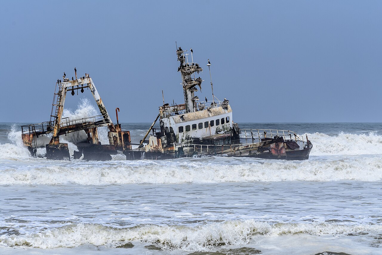
The coast’s most famous survivor story is that of the Dunedin Star, a British cargo liner that struck rocks near the Uniab River mouth in 1942. The ship was carrying mail and passengers; 106 people made it ashore and were eventually rescued after weeks of improvised survival, including a celebrated trek south by a small group. The wreck’s rusting hull is still visible today — one of the most photographed relics on the coast.
Other losses include the Eduard Bohlen, a German cargo ship that ran aground in 1909 near Conception Bay and now sits half-buried in sand, hundreds of metres from the waterline as the shoreline has shifted. The Shawn Fang, a fishing trawler wrecked in 1987 near the Huab River mouth, is another landmark. These wrecks are not just curiosities; they are records of a maritime highway that has claimed vessels for five centuries.
Where Exactly Is the Skeleton Coast — and Who Lives There?
The coast lies in the Kunene and Erongo regions of northwestern Namibia. Its southern section falls within the Skeleton Coast National Park, proclaimed in 1971, which covers about 16,400 square kilometres. The northern section, from the Ugab River to the Kunene, is part of the Skeleton Coast Park proper and is largely restricted, accessible only with permits and usually via organised fly-in safaris.
The coast is not empty of people. The Topnaar, also known as the ≠Aonin, are a Nama-speaking community who have lived along the Kuiseb River for centuries. They are famous for harvesting !nara melons — a staple food and source of income — and for their deep knowledge of desert survival. Their presence is a reminder that the “skeleton” narrative of emptiness is a colonial lens; indigenous people have thrived here for generations.
Getting There: Practical Realities
- Southern access: The coastal towns of Swakopmund and Henties Bay are the main gateways. From Henties Bay, the C34 heads north toward the park’s southern gate at Ugab.
- Northern access: The remote northern section is typically reached by light aircraft from Swakopmund or Windhoek, landing at airstrips such as those near Terrace Bay or Möwe Bay.
- Permits: Entry to the national park requires a permit from Namibia Wildlife Resorts; the northern section is more restricted than the south.
What Makes the Skeleton Coast’s Landscape So Extraordinary?
This is a place where two deserts meet the ocean. The Namib, the world’s oldest desert, pushes right up to the Atlantic, and the cold Benguela Current creates a fog belt that rolls inland most mornings. The result is a landscape of towering dunes, gravel plains, salt pans, and rocky outcrops — all washed in a pale, otherworldly light.
The fog is not just atmospheric; it is the engine of life. Moisture from fog sustains lichens, beetles, and the famous Welwitschia mirabilis, a plant that can live for over a thousand years and survives on fog and rare rain. The coast’s geology is equally striking: the Messum Crater, a collapsed volcanic structure inland from the coast, and the salt pans near Cape Cross are geological wonders in their own right.
Wildlife Adapted to a Harsh World
The Skeleton Coast’s wildlife is a study in adaptation. Desert-adapted lions — famously the subject of long-term research by the Namibia-based charity Desert Lion Conservation — roam the northern reaches, preying on oryx and other antelope. Desert elephants, smaller and with longer legs than their savanna cousins, move between water sources. Brown hyenas patrol the beaches, scavenging seal carcasses. At Cape Cross, one of the world’s largest Cape fur seal colonies draws thousands of animals — and the predators that follow them.
Birdlife is rich too: flamingos gather at the coastal salt pans, and the coast is a stopover for migratory species. The marine environment, fed by the nutrient-rich Benguela, supports fisheries that have shaped Namibia’s economy — though overfishing has been a persistent challenge.
A Timeline of the Skeleton Coast: Key Dates and Events
| Year | Event | Significance |
|---|---|---|
| 1485 | Portuguese navigator Diogo Cão reaches the coast | Early European contact; the region appears on Portuguese maps |
| 1909 | The Eduard Bohlen runs aground near Conception Bay | One of the coast’s most famous wrecks, now stranded inland by shifting sand |
| 1942 | The Dunedin Star wrecks near the Uniab River | 106 survivors; a celebrated rescue and survival story |
| 1971 | Skeleton Coast National Park proclaimed | Formal protection of the southern section’s ecosystems |
| 1987 | The Shawn Fang trawler wrecks near the Huab River | Modern reminder of the coast’s navigational hazards |
How Did the Skeleton Coast Become a National Park?
Namibia’s conservation story is one of the continent’s most interesting. After independence in 1990, the country pioneered “communal conservancies” — areas where communities manage wildlife and tourism on their own land. The Skeleton Coast National Park predates independence, proclaimed in 1971 under South African administration, but its modern management reflects Namibia’s community-based approach.
The park is managed by Namibia Wildlife Resorts in partnership with the Ministry of Environment, Forestry and Tourism. Tourism is deliberately low-volume: the northern section is restricted, and much of the coast is accessible only by air. This is conservation by scarcity — keeping visitor numbers low to protect fragile ecosystems.
Conservation Challenges and Successes
The coast faces pressures familiar across Africa: climate change altering fog patterns, mining interests (including offshore diamond and oil exploration), and the tension between tourism revenue and ecological protection. Yet there are successes. Desert-adapted wildlife populations have been monitored closely, and the Namibian model of community conservancies has been studied worldwide.
- Fog dependence: Species like Welwitschia and coastal lichens rely on fog; changing climate patterns could disrupt them.
- Mining pressure: Offshore exploration for diamonds and oil raises questions about spill risks in a pristine marine environment.
- Tourism balance: Low-volume, high-value tourism funds conservation but limits access for ordinary Namibians.
What Can Visitors Actually See and Do on the Skeleton Coast?
This is not a beach holiday destination. The coast rewards travellers who come for wilderness, history, and wildlife — and who accept its restrictions. The southern section around Swakopmund and Henties Bay is accessible by road; the northern section requires permits and usually a fly-in safari.
Key Sites Along the Coast
Cape Cross is home to a massive Cape fur seal colony and a stone cross erected by Diogo Cão in 1486 (a replica stands today; the original is in a Berlin museum). Terrace Bay is a small settlement with a shipwreck offshore and a reputation for excellent fishing. Möwe Bay is a research and conservation base in the remote north. The Ugab River marks the southern boundary of the restricted park section.
For those with permits, the northern coast offers some of the most isolated landscapes in Africa: endless beaches, shipwrecks, and the chance to see desert-adapted lions and elephants. Fly-in safaris typically include guided drives, visits to seal colonies, and stops at wreck sites.
Why Does the Skeleton Coast Matter Beyond Namibia?
The coast is a global reference point for several reasons. Its shipwrecks are a maritime archaeological record spanning centuries of trade, exploration, and migration. Its desert-adapted species — lions, elephants, Welwitschia — are evolutionary case studies. And its conservation model, combining national parks with community conservancies, has influenced policy across southern Africa.
The coast also sits within the Benguela Current Large Marine Ecosystem, one of the world’s most productive marine systems. The cold current supports fisheries that feed millions across the region, and its fog-driven ecology is increasingly studied by climate scientists. For the African diaspora, the coast is a reminder that the continent’s stories are not only about savannas and cities but also about remote, elemental places where human history and natural history are inseparable.
What Does the Future Hold for the Skeleton Coast?
The coast’s future depends on balancing protection with pressure. Namibia’s government has pursued offshore oil and gas exploration, and the coast’s remoteness makes it both attractive for industry and vulnerable to accidents. At the same time, tourism — particularly high-end, low-impact travel — offers a sustainable revenue stream.
Climate change is the wildcard. The Benguela Current’s behaviour, fog frequency, and rainfall patterns are all shifting, with uncertain consequences for species adapted to precise conditions. Researchers continue to monitor desert-adapted lions and elephants, whose movements reveal how wildlife copes with a changing desert.
The Skeleton Coast’s Lasting Lesson
The Skeleton Coast earns its name honestly, but it is not a place of death. It is a place of adaptation — of plants that drink fog, lions that cross dunes, and people who have lived along the Kuiseb for generations. Its wrecks are monuments to human ambition and human error, and its protected status is a monument to a different kind of ambition: the decision to leave a place wild. For travellers willing to accept its restrictions and its fog, the coast offers something increasingly rare in the modern world — a landscape that remains genuinely untamed.