📅 Last updated: 23.09.2026
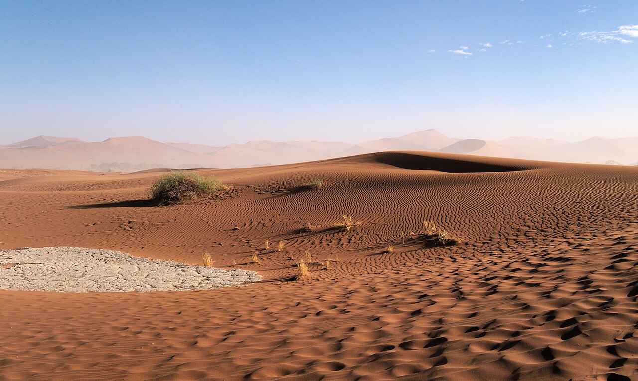
The Sossusvlei dunes rise out of the Namib Desert like a slow-motion ocean of iron oxide, cresting more than 300 metres above a white clay pan that is dry for most of the year. They sit inside Namib-Naukluft National Park, part of the oldest desert on Earth, in a country that receives less rainfall than almost any other. And yet nothing about Sossusvlei is barren in the way the word “desert” suggests. Fog rolls in from the Atlantic, beetles and lizards drink it, gemsbok track across the interdunes, and at dawn the sand turns from apricot to blood-orange to a deep theatrical red — one of the great light shows on the planet.
- Where the Sossusvlei Dunes Actually Are
- How the Sossusvlei Dunes Were Built
- Reading the Sossusvlei Dunes Through the Fog
- Wildlife of the Dune Sea
- People of the Namib: The Topnaar and the Wider Region
- Visiting the Sossusvlei Dunes: Practical Realities
- The Sossusvlei Dunes in Culture and Image
- Conservation Challenges and the Road Ahead
- Why the Sossusvlei Dunes Still Matter
This is a landscape that rewards specificity. The dunes have names, ages, and measurable physics. The pans have hydrology. The people who live nearby have histories that stretch back centuries and forward into a modern, independent Namibia. Understanding Sossusvlei means understanding all of it at once: geology, climate, wildlife, human culture, and the careful politics of visiting a place this fragile.
Where the Sossusvlei Dunes Actually Are
Sossusvlei lies in the Namib Desert of central-western Namibia, roughly 300 kilometres southwest of the capital, Windhoek, and about 60 kilometres inland from the Atlantic coast. Administratively, it sits within the Namib-Naukluft National Park, which was expanded in 1979 and now covers nearly 50,000 square kilometres — one of the largest protected areas in Africa. The nearest settlement of any size is Sesriem, whose gate is the main entry point for visitors; the small tourism village of Sesriem has grown around that gate, with lodges, a fuel station, and a campsite operated inside the park.
The name “Sossusvlei” is usually translated from a Nama word as “dead-end marsh” — sossus suggesting a place where water collects and stops, vlei the Afrikaans term for a shallow, seasonal pan or marsh. That etymology matters, because Sossusvlei is not really about the dunes alone. It is about the meeting point of dunes and water.
The vlei system: Sossusvlei, Deadvlei, Hiddenvlei
Several clay pans sit at the end of the Tsauchab River’s ephemeral course. The main one is Sossusvlei itself; nearby are Deadvlei, Hiddenvlei, and Nara Vlei. When the Tsauchab floods after exceptional rain in the Naukluft Mountains to the east — perhaps once every few years, sometimes once a decade — water reaches these pans and briefly turns them into mirror-flat lakes that reflect the dunes. Most years, the river soaks away into the sand long before it arrives, and the pans stay bone-white and cracked.
Deadvlei is the most photographed of them all: a white clay floor scattered with the blackened skeletons of camelthorn trees (Acacia erioloba) that died roughly 600 to 900 years ago when the sand blocked the water channel. Because the air is so dry, the wood never rotted. It simply stood there, carbonised by sun, until photographers made it famous.
How the Sossusvlei Dunes Were Built
The dunes are the product of an unusual chain of events that began millions of years ago. Sand carried down the Orange River to the Atlantic coast was swept north by the cold Benguela Current, deposited along the shore, and then driven inland by strong prevailing southwesterly winds. Over immense spans of time, that sand accumulated into the dune sea that now runs roughly 400 kilometres along the coast and up to 130 kilometres inland.
Geologists distinguish several dune types here, and the distinctions are visible to the naked eye once you know what you are looking at:
- Star dunes — pyramidal, with arms radiating in multiple directions, formed where wind patterns shift unpredictably.
- Transverse dunes — long, parallel ridges aligned perpendicular to the dominant wind, which is what most visitors picture when they imagine Sossusvlei.
- Linear or longitudinal dunes — the long “seif” dunes that stretch across the dune sea, sometimes running for tens of kilometres.
- Barchan dunes — crescent-shaped and mobile, common on the sandier margins where sand supply is limited.
The famous big dunes at Sossusvlei — Dune 45, Big Daddy, Big Mama, Elim Dune — are mostly star and transverse forms stacked and welded together by wind over hundreds of thousands of years. Big Daddy, near Deadvlei, is often cited as roughly 325 metres high, making it among the tallest dunes in the world; the exact figure depends on where you measure from, since the base shifts with the sand.
Why the sand is red
The colour comes from iron oxide coatings on the quartz grains. Older sand, exposed longer to the air and to chemical weathering, carries a thicker iron coating and reads deeper red; younger sand, nearer the coast, is paler and more yellow. The gradient from the coast inland is therefore also a gradient in time. The Sossusvlei dunes are among the oldest and reddest in the Namib, which is one reason photographs from this area look so unlike dunes anywhere else.
Reading the Sossusvlei Dunes Through the Fog
Sossusvlei’s climate is a study in contradiction. Rainfall here averages well under 100 millimetres a year, and multi-year droughts are normal. Yet humidity arrives almost every morning in the form of fog, pushed inland by the cold Benguela Current and the prevailing southwesterly winds. This fog is the desert’s hidden water supply, and an astonishing number of species have evolved to exploit it.
The most famous is the Namib desert beetle (Stenocara gracilipes), whose bumpy back condenses fog droplets that then roll into its mouth. The Namib sand-diving lizard (Aporosaura anchietae) flattens itself against dune crests to collect fog on its skin. The Welwitschia mirabilis, a living fossil plant found in the northern Namib, can survive for over a thousand years on fog and rare rain. These adaptations are not curiosities; they are the reason the Namib is considered one of the world’s great laboratories of evolutionary biology.
“The Namib is not a place where life struggles to exist. It is a place where life has solved the problem of existence in ways we are still learning to understand.” — a sentiment repeatedly voiced by Namibian desert ecologists, and one that captures why the park’s research programme matters far beyond tourism.
Temperature swings are equally dramatic. Summer days can exceed 40°C; winter nights in the same spot can fall close to freezing. The dunes themselves act as heat reservoirs and radiators, warming fast after sunrise and releasing heat after dark, which drives local wind patterns and helps explain why the sand surface can be 20°C hotter than the air a metre above it.
Wildlife of the Dune Sea
Visitors often arrive expecting emptiness and leave surprised by how much moves. The Namib’s wildlife is sparse but specialised, and much of it is best seen in the early morning or late afternoon.
Mammals
Gemsbok (oryx) are the emblematic antelope of the dune sea, able to go without drinking water for weeks and to extract moisture from the plants they eat. Springbok, bat-eared foxes, black-backed jackals, and the occasional brown hyena also range through the park. The dunes are not a barrier to them; they are a habitat.
Reptiles, birds, and insects
The Namib is exceptionally rich in reptiles, with many endemic species. The dunes host sand snakes, geckos, and the famous sidewinding adder. Birdlife includes the Ludwig’s bustard, the dune lark, and — for the lucky — the secretarybird. Insect life is dominated by tenebrionid beetles, fog-basking specialists whose tracks are often the first thing you notice on a clean dune face at dawn.
Sossusvlei’s plant life
Vegetation is concentrated in the interdunes and pans, where moisture lingers longer. Camelthorn trees anchor the older dune corridors; !nara bushes (Acanthosicyos horridus) grow in the sandy plains and produce melons that sustained the Topnaar people for centuries. The !nara is a good example of how the desert’s ecology and its human history are inseparable.
People of the Namib: The Topnaar and the Wider Region
The Namib has been inhabited for a very long time. Archaeological evidence from the wider region — including sites in the Kuiseb River valley and along the coast — shows human presence stretching back tens of thousands of years. The Topnaar (also written ǂAonin), a Nama-speaking people, have lived along the Kuiseb River and the central Namib coast for centuries, harvesting !nara melons, herding goats, and trading with coastal communities.
Today the Topnaar number in the thousands and live in several small settlements along the Kuiseb, including places like Utuseb and Rooibank. They hold communal land rights and continue to harvest !nara, though their livelihoods are increasingly shaped by tourism, conservation agreements, and the modern Namibian economy. Their presence is a reminder that the Namib is not an empty wilderness; it is a homeland.
Namibia itself gained independence from South African administration in 1990, following a long liberation struggle led by SWAPO and shaped by international diplomacy. Since then, the country has built one of Africa’s more robust tourism sectors, and Sossusvlei is one of its flagship destinations. Community-based natural resource management programmes — known locally as conservancies — have given many rural Namibians a direct stake in wildlife and landscape conservation. These programmes are not perfect, but they are widely cited as a model for how conservation and local livelihoods can be aligned.
Visiting the Sossusvlei Dunes: Practical Realities
Getting to Sossusvlei takes planning. Most visitors fly into Hosea Kutako International Airport near Windhoek and drive or fly to Sesriem. The drive from Windhoek is roughly five to six hours on gravel and tar roads; self-drive is common, but so are guided tours and small-plane charters to airstrips near Sesriem and Wolwedans.
Inside the park, the key logistical fact is that the gate at Sesriem opens at sunrise and closes at sunset, and the last stretch to Sossusvlei — about 60 kilometres from the gate — is on a tarred road that becomes deep sand for the final five kilometres. Most visitors park at a 4×4 shuttle point and ride the last stretch in a park-approved vehicle. Climbing Dune 45 is a popular early-morning activity; it is not technically difficult, but the sand is soft and the altitude gain is real.
When to go
May to September is the cooler, drier high season, with clear skies and comfortable daytime temperatures. October to April is hotter, with a chance of dramatic thunderstorms and, occasionally, water in the vleis. Photographers often prefer the shoulder months for the combination of light quality and manageable heat.
What it costs and how to do it responsibly
Park entry fees are modest by international standards and are paid at the Sesriem gate; rates differ for Namibian residents, SADC nationals, and other international visitors. Accommodation ranges from the park campsite at Sesriem to luxury lodges on private concessions bordering the park. The main environmental issues are straightforward: stay on marked routes, do not climb dunes outside designated areas, carry out everything you bring in, and respect the heat. Drones are heavily restricted in Namibian national parks, and permits are required.
| Key fact | Detail |
|---|---|
| Location | Namib-Naukluft National Park, central-western Namibia |
| Nearest gate | Sesriem, about 60 km from Sossusvlei |
| Tallest nearby dune | Big Daddy, roughly 325 m |
| Annual rainfall | Generally under 100 mm |
| Best months | May–September for cooler weather |
| Famous landmark | Deadvlei’s fossilised camelthorn trees |
The Sossusvlei Dunes in Culture and Image
Sossusvlei has become one of the most recognisable landscapes in Africa, appearing in films, advertising campaigns, and countless travel photographs. That visibility has real consequences. It brings revenue and international attention to Namibia, and it supports thousands of jobs in tourism and hospitality. It also creates pressure: dune erosion from foot traffic, waste management challenges, and the risk that the place becomes a backdrop rather than a place with its own logic.
Namibian photographers, guides, and conservationists have pushed back against the simplest versions of the Sossusvlei image. They point out that the dunes are alive — moving, breathing, changing — and that the most interesting stories are not the postcard shots but the ecology underneath them. The rise of astro-tourism in the Namib, the growing interest in the region’s geology, and the work of organisations like the Namib Desert Environmental Education Trust (NaDEET) all reflect a shift toward deeper engagement.
There is also a literary and artistic tradition here. Namibian and South African writers have long used the desert as a space for thinking about time, survival, and belonging. The !nara harvest, the Topnaar language, and the Nama place names that dot the map are part of that tradition — living culture, not decoration.
Conservation Challenges and the Road Ahead
The Namib-Naukluft park is large, but it is not immune to pressure. Climate change is altering rainfall patterns and fog frequency; some models suggest the Namib’s fog belt could shift or weaken, with serious implications for fog-dependent species. Mining — including uranium extraction near Swakopmund and inland — competes for water and land in the wider region. Off-road driving, illegal sand mining, and unregulated tourism all pose local threats.
Against this, Namibia has genuine strengths. The country’s constitution was among the first in the world to include environmental protection as a guiding principle. Community conservancies now cover a substantial share of Namibia’s land area, and tourism concession fees help fund park management. Research stations and universities, both in Namibia and abroad, continue to study the desert’s climate and biology. The Sossusvlei dunes are not just a scenic asset; they are a test case for whether a country can turn extraordinary natural heritage into durable, equitable development.
Why the Sossusvlei Dunes Still Matter
Standing on a dune crest at first light, you can see the mechanics of deep time at work: sand moving grain by grain, fog burning off, a landscape that has been shaped by the same processes for millions of years. The Sossusvlei dunes are not a museum piece. They are an active system, and the people, plants, and animals around them are part of that system. To visit well is to understand that you are a brief participant in something much older and much larger.
That is the real takeaway. Sossusvlei is not just Namibia’s most photographed place; it is a lesson in how deserts work, how life adapts, and how a young nation is choosing to steward one of the planet’s most singular landscapes. Go for the light. Stay for the complexity.