📅 Last updated: 21.09.2026
The Aïr Mountains Niger rise like a stone sea from the Sahel, a jagged island of volcanic peaks and sandstone plateaus stranded in a desert that stretches from the Atlantic to the Red Sea. They are the highest ground in Niger and, by many measures, the most beautiful landscape in the central Sahara. For at least eight thousand years, people have lived among these peaks, carving a civilization out of rock, grazing goats on highland pastures, and guarding caravan routes that once carried salt, gold, and ideas across the continent. To visit the Aïr is to discover a Sahara that is not empty at all — but layered with cities of mud and stone, prehistoric art galleries, and cultures that have endured in one of the harshest environments on Earth.
- Where the Aïr Mountains Niger Stand on the Map
- Reading the Rocks: Geology and Prehistory in the Aïr Mountains Niger
- Agadez: Gateway to the Aïr Mountains Niger
- People of the High Country: Tuareg, Wodaabe, and Beyond
- Wildlife and the Fight to Protect a Fragile Land
- Travel and Adventure in the Aïr
- Music, Memory, and Modernity
- Aïr Mountains Niger: A Wonder Worth Knowing
Where the Aïr Mountains Niger Stand on the Map
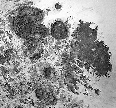
The Aïr massif occupies roughly 70,000 square kilometres of northern Niger, rising from the Sahelian plains around the town of Agadez and running north toward the Ténéré desert and the Algerian border. Its highest point, Mount Idoukal-n-Taghès, reaches about 2,022 metres — modest by alpine standards, but a dramatic skyline in a country where the average elevation is barely 300 metres. Geologically, the range is a mix of ancient crystalline basement rock, volcanic plugs, and sandstone plateaus, formed by tectonic uplift hundreds of millions of years ago and sculpted ever since by wind and flash floods.
The mountains sit at the crossroads of two worlds. To the south lies the Sahel, with its thorn trees and seasonal grasses; to the north, the true desert of the Ténéré. This position gives the Aïr a remarkable ecological range. In the high valleys, isolated pockets of relict vegetation survive — wild olives, figs, and even a few crocodiles in the guelta of Timia, tiny aquatic holdovers from a much wetter Sahara. The Aïr and Ténéré National Nature Reserve, established in 1988 and later expanded into the Aïr and Ténéré Natural Reserves, was inscribed as a UNESCO World Heritage Site in 1991. It is one of the largest protected areas in Africa, covering around 7.7 million hectares, and it shelters species including the addax, the dama gazelle, and the Barbary sheep, known locally as the oudad.
“The Aïr is not a desert in the ordinary sense. It is a mountain archipelago in a sea of sand, and everything about it — its people, its wildlife, its history — flows from that fact.”
Reading the Rocks: Geology and Prehistory in the Aïr Mountains Niger
Long before the Sahara was dry, the Aïr was green. During the African Humid Period, roughly 11,000 to 5,000 years ago, monsoon rains reached far north of their present limit. Lakes filled the basins, grasslands covered the plains, and animals we now associate with the savanna — elephants, giraffes, rhinoceroses, hippos — roamed what is now desert. Humans followed the water, and they left behind one of the world’s great open-air art galleries.
The rock art of the Aïr is extraordinary in both quantity and quality. Thousands of engravings and paintings are scattered across the massif, especially around the valleys of the Taghès and the plateau of Dabous. The most famous single image is the Dabous Giraffe, a pair of life-sized giraffes carved into a sandstone outcrop roughly 8,000 years ago — the larger animal stands about 5.4 metres tall, making it one of the largest known prehistoric rock carvings in the world. Around it are hundreds of smaller figures: cattle with sweeping horns, ostriches, lions, and human hunters with bows.
The art tells a story of environmental change. Early engravings show the “Ethiopian” fauna of a wetter world; later images shift to cattle herding, then to horses and camels, tracking the Sahara’s slow desiccation and the arrival of new peoples and technologies. By around 2,000 years ago, the desert had largely taken hold, and the Aïr’s inhabitants had adapted — becoming the pastoralists, traders, and caravaners whose descendants live there today.
A Timeline of the Aïr
| Period | Key Development |
|---|---|
| c. 10,000–5,000 BCE | African Humid Period; lakes, grasslands, and early human settlement |
| c. 6,000 BCE | Dabous giraffes carved; great era of rock art |
| c. 1,000 BCE–500 CE | Desertification; shift to pastoralism and trans-Saharan trade |
| 11th–15th centuries | Agadez flourishes as a caravan hub; Islam spreads through the region |
| 1449 | Sultanate of Aïr established at Agadez under the Tuareg |
| 1991 | Aïr and Ténéré Natural Reserves inscribed as a UNESCO World Heritage Site |
Agadez: Gateway to the Aïr Mountains Niger
No account of the Aïr makes sense without Agadez. Founded by Tuareg clans in the eleventh century and later the seat of the Sultanate of Aïr, the city grew rich on the trans-Saharan trade. From its gates, caravans struck north across the Ténéré to the salt mines of Bilma and on to Libya and the Mediterranean; southward, they carried goods toward Kano and the forest belt. At its height, Agadez was a meeting point for Tuareg, Hausa, Fulani, and Arab traders, and a centre of Islamic scholarship.
The city’s defining monument is the Grand Mosque of Agadez, whose mud-brick minaret rises about 27 metres — the tallest earthen structure of its kind. Its tapering, spiked form is built entirely of banco, a sun-dried mud and straw mixture, and it is repaired by the community every year in a traditional festival. Around it, the old town’s labyrinth of ochre houses, some decorated with geometric relief patterns, still feels like a living museum. In 2013, UNESCO added the Historic Centre of Agadez to its World Heritage list, recognizing it as “the oldest and best-preserved example of a Saharan earthen architecture.”
Agadez is also a modern city, with an international airport, a university, and a young population that moves between pastoral traditions and urban life. It remains the essential base for anyone exploring the Aïr, and a reminder that the Sahara’s history is one of cities and connections, not just dunes and isolation.
People of the High Country: Tuareg, Wodaabe, and Beyond
The Aïr is the heartland of the Tuareg, the Amazigh (Berber) pastoralists who call themselves Kel Tamasheq — “those who speak Tamasheq.” Their culture is inseparable from the mountains. Tuareg society has historically been organized into confederations, with the Kel Aïr (or Kel Owey) among the most prominent in the massif. Men wear the tagelmust, the indigo veil that gives them the romanticized name “blue men of the desert,” while women hold notable authority in family and cultural life, including the transmission of the Tifinagh script.
Alongside the Tuareg, the Wodaabe Fulani bring their cattle to the southern fringes of the Aïr and the Sahel. Each year after the rains, Wodaabe men compete in the Gerewol, a flamboyant beauty contest of dancing, chanting, and elaborate makeup — one of the most photographed cultural events in Africa. The Aïr’s economy also includes settled communities of Hausa farmers in the valleys, Kanuri traders, and Arab families, all bound together by markets, marriage, and the shared demands of desert life.
How People Live in the Aïr
- Transhumance: Herders move their goats, sheep, and camels between lowland pastures in the dry season and highland grazing after the rains.
- Oasis agriculture: In valleys such as Timia and Tabelot, date palms, figs, and vegetable gardens are irrigated by foggara — ancient underground channels that tap groundwater and carry it by gravity to the fields.
- Caravan trade: Though diminished, camel caravans still haul salt and dates along routes that have functioned for a thousand years.
- Silverwork: Agadez’s artisans are famous for Tuareg silver jewellery — crosses, rings, and amulets whose geometric designs are prized across the Sahel and in diaspora markets.
Wildlife and the Fight to Protect a Fragile Land
The Aïr’s wildlife is sparse but precious. The addax, a pale antelope exquisitely adapted to deserts, once ranged widely across the massif; today it is critically endangered, with only a few hundred animals surviving in the wild, mostly in Niger. The dama gazelle and the dorcas gazelle cling on in the reserve, alongside Barbary sheep, rock hyraxes, and a surprising variety of reptiles and birds. The mountains also lie on a major migratory flyway, and seasonal wetlands attract waterbirds that seem impossibly out of place in the sand.
Protecting this landscape is hard. Poaching, overgrazing, drought, and the pressures of a growing population all take a toll. The Aïr and Ténéré reserves have faced additional strain from insecurity in the wider Sahel region, which has disrupted tourism and conservation work since the 2000s. Yet Nigerien rangers, community conservancies, and international partners continue the effort, and the 1991 UNESCO listing remains a powerful tool for attracting attention and funding.
There is also a deeper truth the Aïr illustrates: deserts are not wastelands. They are complex ecosystems that have supported human life for millennia, and their fate is tied to how the world manages climate change, water, and land use far beyond their borders.
Travel and Adventure in the Aïr
For decades, the Aïr was one of Africa’s great adventure destinations. Travellers came to cross the Ténéré by 4×4, to see the Dabous giraffes at sunrise, to swim in the guelta of Timia, and to sleep under a sky so clear the Milky Way casts shadows. The classic route ran from Agadez north to the oasis of Timia, then east through the Aouderas valley toward the Ténéré and the dunes of the Erg du Ténéré.
Today, travel to the Aïr requires careful planning and attention to security conditions. Many Western governments advise against non-essential travel to northern Niger, and tourism has fallen sharply since the 2007 Tuareg rebellion and subsequent regional instability. But domestic tourism and diaspora visits continue, and the infrastructure — guesthouses in Agadez, Tuareg-run camps, and experienced guides — remains. For those who go with reputable local operators, the reward is an encounter with a living desert culture that has few equals.
Practical Highlights for a Future Visit
- Agadez old town and Grand Mosque — a UNESCO World Heritage Site and the cultural capital of the Aïr.
- Dabous rock art — the 8,000-year-old giraffes, among the world’s largest petroglyphs.
- Timia oasis — palm groves, gardens, and the famous guelta with its resident crocodiles.
- The Aïr highlands — volcanic peaks, basalt columns, and panoramic views over the Ténéré.
- Tuareg camps and markets — silverwork, indigo veils, and the rhythms of desert hospitality.
Music, Memory, and Modernity
The Aïr has produced some of the most internationally celebrated music in Africa. Tuareg guitar music — often called “desert blues” — emerged from the experiences of young men in exile and rebellion in the 1980s and 1990s, blending Tamasheq poetry with electric guitars and rock rhythms. Bands such as Tinariwen, formed in the Aïr region and the Libyan camps, won a Grammy Award in 2012 and brought the sound of the Sahara to global audiences. Their songs speak of homeland, loss, and the long struggle for a place in the modern world.
This musical movement is more than entertainment. It is a form of memory and diplomacy, connecting the Aïr to the diaspora in Europe and North America and giving young Tuareg a voice that reaches far beyond the mountains. At festivals in Agadez and abroad, the old and the new sit side by side: camel caravans and smartphones, Tifinagh script and streaming platforms, ancient rock art and electric guitars.
Aïr Mountains Niger: A Wonder Worth Knowing
The Aïr Mountains Niger are not a postcard desert. They are a place of real people, real history, and real challenges — a highland refuge where Tuareg herders, Hausa farmers, and Wodaabe pastoralists have adapted to a changing climate for thousands of years. They hold some of the oldest art on Earth, one of the Sahara’s great caravan cities, and ecosystems that survive against the odds. They are also under pressure, from drought, insecurity, and the global forces that shape the Sahel.
To know the Aïr is to understand that the Sahara has never been empty, and that Africa’s heritage is not confined to the pyramids or the savanna. It is here, in the stone and mud and music of a mountain range in Niger, where the desert itself becomes a story of endurance, creativity, and connection. Whether you travel there in person or through its art and songs, the Aïr leaves a mark — a reminder that wonder can grow in the driest places, and that the people who tend it deserve the world’s attention.