📅 Last updated: 05.11.2026
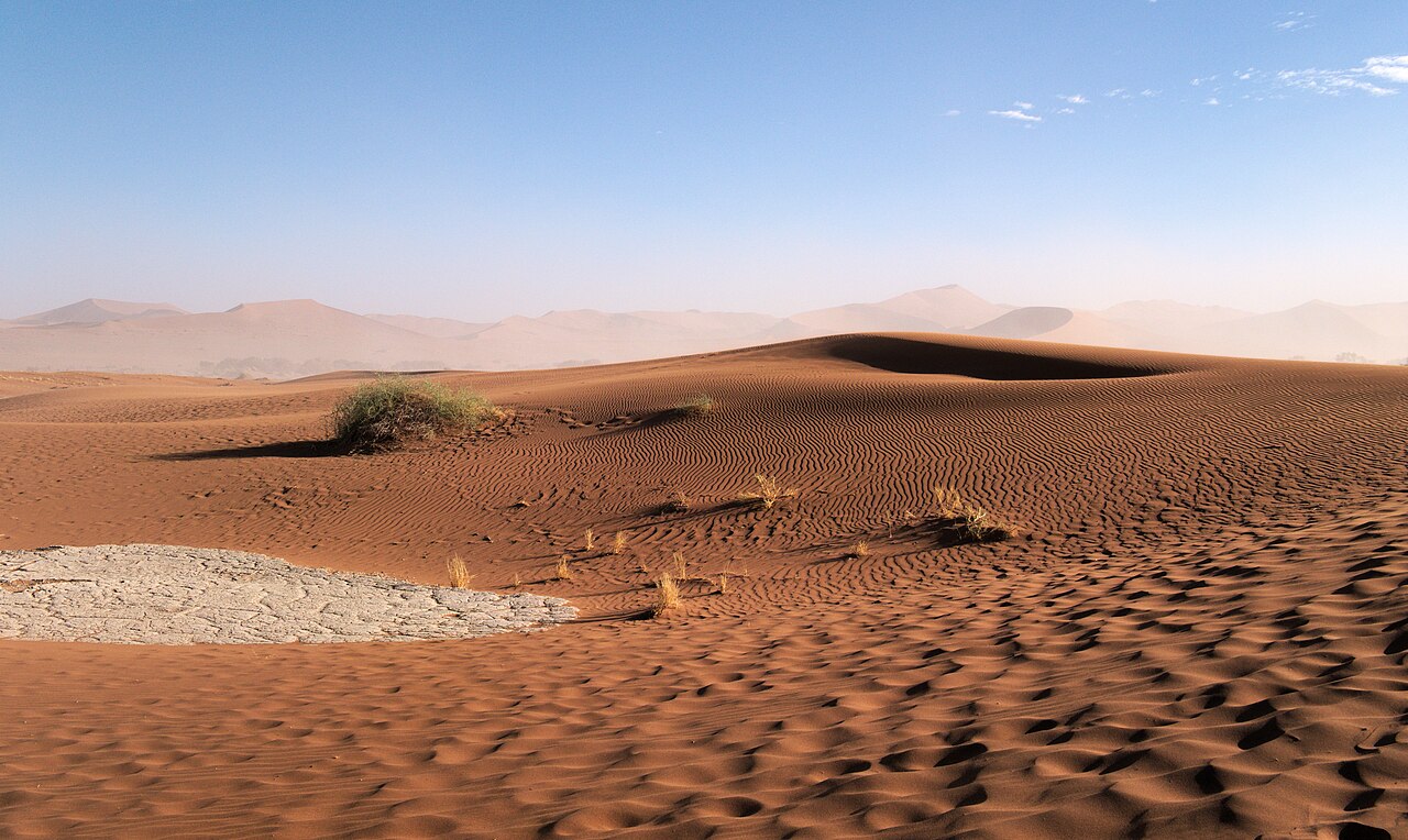
The Sossusvlei dunes rise from the Namib Desert floor like a frozen red ocean, their crests shifting with every wind that crosses the world’s oldest desert. Stretching across the heart of the Namib-Naukluft Park in western Namibia, the Sossusvlei dunes form the most photographed sand landscape on Earth — a 32,000-square-kilometre expanse of star dunes, linear ridges, and clay pans where the Tsauchab River dies before reaching the Atlantic. This is a place of extremes: 300-metre peaks, surface temperatures that exceed 70°C, and fog that rolls in from the coast to sustain beetles, lizards, and the ancient welwitschia plant. To understand Sossusvlei is to understand how geology, climate, and human history converge in one of Africa’s most striking environments.
The Sossusvlei dunes are a field of star and linear sand dunes in Namibia’s Namib Desert, part of the Namib-Naukluft Park. The tallest, known as “Big Daddy,” rises roughly 325 metres above the surrounding vlei floor, making it among the highest dunes in the world. The sand is red because of iron oxide coatings on quartz grains, some of which have travelled more than a thousand kilometres from the Orange River via the Atlantic Ocean and prevailing winds.
- Where Are the Sossusvlei Dunes and Why Do They Exist?
- How Were the Sossusvlei Dunes Formed?
- What Makes the Sossusvlei Dunes So Tall and So Red?
- Dead Vlei and the Hidden Water Stories of the Sossusvlei Dunes
- Life in the Sossusvlei Dunes: Fog, Beetles, and Desert Adapted Species
- Visiting the Sossusvlei Dunes: Practical Guide and Key Facts
- Cultural and Conservation Context: The People Behind the Dunes
- Why the Sossusvlei Dunes Matter Beyond Namibia
- The Lasting Perspective: A Desert That Rewards Attention
Where Are the Sossusvlei Dunes and Why Do They Exist?
Sossusvlei sits in the Sesriem district of the Hardap Region, roughly 350 kilometres southwest of Windhoek by road. The name itself is a hybrid: “Sossus” from the Nama word for “dead-end” or “blind river,” and “vlei” from Afrikaans for a shallow marsh or pan. The Tsauchab River, a seasonal watercourse that rises in the Naukluft Mountains to the east, flows west toward the coast but is blocked by a wall of dunes about 60 kilometres inland. The river spreads into a series of clay pans — Sossusvlei, Dead Vlei, Nara Vlei — and evaporates or sinks into the sand. It has not reached the Atlantic in recorded history.
The dunes exist because of a rare convergence of forces. Sand eroded from the Kalahari and the Orange River system is carried north along the coast by the cold Benguela Current, then blown inland by southwesterly winds. As the sand moves east, it encounters the Tsauchab’s floodplain and other topographic barriers, and it piles up. Over millions of years, the grains have been sorted, rounded, and coated in iron oxide — the source of the deep red, apricot, and rust tones that shift through the day as the sun angle changes.
The Namib is generally considered the world’s oldest desert, with arid conditions dating back at least 55 million years. The sand sea itself is younger — much of the surface sand has been dated to the Quaternary — but the dune system has been building and reshaping for a very long time. The Namib-Naukluft Park, which contains Sossusvlei, was proclaimed in 1907 as Game Reserve No. 3 under German colonial administration, making it one of Africa’s oldest protected areas. It was expanded and renamed over the 20th century, and today covers 49,768 square kilometres.
How Were the Sossusvlei Dunes Formed?
The formation story is a chain of geological events that stretches from the Drakensberg Mountains to the Atlantic seabed. Sand particles eroded from southern Africa’s interior are washed into the Orange River, carried to the sea, and deposited along the Namaqualand coast. The Benguela Current — a cold, nutrient-rich upwelling that also sustains Namibia’s fishing industry — pushes this sediment northward. Onshore winds then transport the sand inland, where it accumulates in the Namib sand sea.
Wind regimes are the sculptors. The prevailing southwesterly wind builds the main dune forms, while easterly winds — especially in winter — reshape the crests and create the complex star dunes found at Sossusvlei. Star dunes form where wind comes from multiple directions, piling sand into a central peak with radiating arms. The linear dunes that dominate much of the sand sea form where winds are more consistent. The result is a dune field of extraordinary variety: transverse dunes, seif dunes, and the towering star dunes that draw photographers from around the world.
The red colour is a chemical signature. Quartz grains are coated with thin films of iron oxide — haematite and goethite — that develop over long periods of exposure. The older the sand surface, the deeper the red. The dunes at Sossusvlei are among the reddest in the Namib, a sign of their age and stability. Underneath the red surface, the sand is often lighter, and in the interdune corridors you can see the stratification of ancient and modern deposits.
- Source: Sand originates largely from the Orange River catchment and coastal deposits, transported north by the Benguela Current.
- Transport: Onshore winds carry sand inland; prevailing southwesterlies and winter easterlies shape dune orientation.
- Colour: Iron oxide coatings on quartz grains produce the red and apricot hues; older surfaces are redder.
- Age: The Namib has been arid for at least 55 million years; the sand sea has been active throughout the Quaternary.
What Makes the Sossusvlei Dunes So Tall and So Red?
Height and colour are linked to stability. The tallest dunes — Big Daddy at roughly 325 metres, Big Mama nearby, and the ridge known as Dune 45 at about 170 metres — form where sand supply is abundant and wind patterns allow accumulation over long periods. Big Daddy is often described as the highest dune in the Namib and among the highest in the world, though measuring dunes is imprecise because crests move. What is certain is that the scale is humbling: climbing Big Daddy from the Dead Vlei side takes most visitors 45 minutes to an hour, and the descent — a plunging run down loose sand — takes minutes.
Dune 45, so named because it lies 45 kilometres from the Sesriem gate, is the most accessible of the great dunes and the one most photographed at sunrise. It rises about 170 metres and offers a ridge walk that is manageable for most fit visitors. The name is purely practical — a distance marker rather than a geological designation — but it has become one of the most recognisable landmarks in Namibia.
The red colour intensifies at dawn and dusk, when low-angle light brings out the iron oxide tones and casts long shadows across the crests. At midday, the contrast flattens and the heat becomes punishing. Photographers time their visits to the “golden hours” for this reason, and the park’s gate opening times — tied to sunrise and sunset — are designed around it.
Dead Vlei and the Hidden Water Stories of the Sossusvlei Dunes
Dead Vlei is the image that most people associate with Sossusvlei: a white clay pan scattered with the blackened skeletons of camel thorn trees, ringed by towering red dunes. The trees died roughly 600 to 900 years ago, when the Tsauchab’s course shifted and cut off their water supply. The dry climate preserved them — no decay, no insects to speak of — and they stand today as a kind of natural sculpture garden. The pan itself is a “vlei” only in name; it floods perhaps once a decade, and when it does, the contrast of water, white clay, and red sand is extraordinary.
Sossusvlei proper, the larger pan nearby, holds water more often and supports a fringe of camel thorn trees and grasses. The name “Sossusvlei” is sometimes used loosely for the whole dune field, but the pan itself is a distinct feature. Nara Vlei, further west, is another clay pan in the chain. These pans are the residue of a river that never reaches the sea — a reminder that in the Namib, water is a visitor, not a resident.
The Tsauchab’s failure to reach the Atlantic is not a recent phenomenon. Geologists have traced the river’s course and found that dune encroachment has blocked it for a very long time. The river’s water instead sustains a linear oasis of trees along its course, and the pans become temporary wetlands after good rains. In years when the Tsauchab floods — most recently in 2011 and again in 2021 — the vlei fills and the desert briefly becomes a lake. These flood events are ecologically important, triggering germination and drawing wildlife.
Life in the Sossusvlei Dunes: Fog, Beetles, and Desert Adapted Species
The Namib’s secret is fog. The cold Benguela Current cools the air over the Atlantic, creating fog that rolls inland at night and early morning. This fog is the primary water source for many desert organisms. The Namib desert beetle (Stenocara gracilipes) captures fog droplets on its bumpy back and channels them to its mouth — a mechanism that has inspired water-harvesting technology. The welwitschia (Welwitschia mirabilis), a gymnosperm that can live for over a thousand years, survives on fog and groundwater, its two long leaves fraying in the wind. Sidewinder snakes, sand-diving lizards, and the translucent Namib dune gecko have all evolved to exploit the fog and the cool sand beneath the surface.
Larger animals are scarce but present. Oryx, springbok, and brown hyena range through the park, and the dunes support a surprising diversity of invertebrates, reptiles, and small mammals. The tok-tokkie beetle, the dancing white lady spider, and the cartwheeling spider are among the desert’s more charismatic residents. Birdlife includes the Ludwig’s bustard and various larks and chats. The fog-driven ecosystem is fragile and finely tuned; off-road driving, which was once common, is now tightly controlled to protect it.
The Namib-Naukluft Park is also home to one of Africa’s most important populations of black rhino, though they are rarely seen in the Sossusvlei area itself. The park’s size and remoteness make it a refuge for species that have disappeared elsewhere in Namibia. Conservation management — including water point provision and anti-poaching patrols — has been central to the park’s success.
Visiting the Sossusvlei Dunes: Practical Guide and Key Facts
Most visitors base themselves at Sesriem, the gateway settlement just outside the park, or at lodges in the surrounding conservancies. The park gate at Sesriem opens at sunrise and closes at sunset, and the 60-kilometre drive to Sossusvlei takes about an hour. The last 5 kilometres are on deep sand and require a 4×4; a shuttle service operates from a car park for those without one. The best months are May to September, when temperatures are cooler and the light is clear. October to March is hot — often above 40°C — but the summer rains can bring dramatic skies and occasional flooding.
| Feature | Detail | Why It Matters |
|---|---|---|
| Location | Namib-Naukluft Park, Hardap Region, Namibia | Roughly 350 km southwest of Windhoek; accessed via Sesriem gate |
| Tallest dune | Big Daddy, approx. 325 m | Among the highest dunes in the world; climbable from Dead Vlei |
| Most accessible dune | Dune 45, approx. 170 m | 45 km from Sesriem gate; popular sunrise climb |
| Park established | 1907 (as Game Reserve No. 3) | One of Africa’s oldest protected areas; now 49,768 km² |
| Sand colour | Red to apricot | Iron oxide coatings on quartz; older surfaces are redder |
| Best season | May–September | Cooler temperatures, clear light, stable road conditions |
Permits are required for entry and are sold at the Sesriem gate or online through Namibia Wildlife Resorts. Day visitors and overnight guests have different access rules — overnight guests can be inside the park at dawn and dusk, which is a significant advantage for photography. The park has a fuel station, shop, and campsite at Sesriem, and several private lodges operate in the surrounding conservancies.
- Book ahead: Accommodation in and around Sesriem fills up in peak season (June–August).
- Carry water: Temperatures can exceed 40°C; dehydration is a real risk on dune climbs.
- Respect closures: Off-road driving and drone use are prohibited; the dunes are a protected ecosystem.
- Time your climb: Start before sunrise for Dune 45 and Big Daddy to avoid heat and catch the best light.
Cultural and Conservation Context: The People Behind the Dunes
The Sossusvlei dunes lie within the traditional territory of the Nama people, whose language gave the place its name. The Nama are among the oldest inhabitants of southern Namibia, with a history of pastoralism and trade that predates European contact. Nearby, the small settlement of Solitaire — famously described as “the last stop before nowhere” — was established as a petrol station and has become a quirky landmark with a bakery and a collection of rusted cars. The area’s human history is thin on the ground but deep in time; rock art and archaeological sites in the wider Namib record thousands of years of human presence.
Conservation is the dominant modern story. The Namib-Naukluft Park is managed by Namibia’s Ministry of Environment, Forestry and Tourism, with support from NGOs and community conservancies. The park is part of the Namib Sand Sea, inscribed as a UNESCO World Heritage Site in 2013 in recognition of its outstanding geological and ecological value. Tourism is a major contributor to Namibia’s economy and a key source of revenue for conservation, though the sector was hit hard by the COVID-19 pandemic and has been rebuilding since 2022.
Climate change is a long-term concern. The Namib is naturally variable, but shifts in fog patterns, rainfall, and wind regimes could alter the dune system and the species that depend on it. Researchers at the Gobabeb Namib Research Institute, established in 1962, have been monitoring the desert for decades and continue to study its ecology and climate. Their work underpins much of what we know about fog harvesting, dune dynamics, and desert adaptation.
Why the Sossusvlei Dunes Matter Beyond Namibia
The Sossusvlei dunes are more than a tourist attraction. They are a natural laboratory for understanding how deserts work — how sand moves, how life adapts to extreme aridity, how fog and wind shape ecosystems. The dune fields of the Namib have informed research on planetary geology, including studies of Mars, where similar dune forms exist. The desert beetle’s fog-harvesting mechanism has inspired engineering solutions for water collection in arid regions. And the park’s conservation model — combining state protection, tourism revenue, and community involvement — is studied across Africa.
For travellers, the dunes offer something increasingly rare: a landscape that is genuinely vast, genuinely wild, and genuinely quiet. Standing on a dune crest at dawn, with the fog burning off the Atlantic and the red sand stretching to the horizon, it is possible to feel the scale of geological time. The Sossusvlei dunes are not a backdrop; they are the main event — a red desert sea that has been shaped by wind and water for millions of years and will continue to shift long after the last visitor has gone home.
The Lasting Perspective: A Desert That Rewards Attention
Namibia’s red desert sea is often reduced to a photograph — the iconic curve of a dune against a blue sky. But the Sossusvlei dunes reward a closer look. The colour is chemistry; the shape is wind; the life is fog and adaptation; the silence is the absence of the noise that fills most of the modern world. The dunes are a reminder that Africa’s landscapes are not just scenic but scientifically and culturally layered, shaped by forces that operate on timescales humans struggle to imagine. To visit is to witness a system in motion — slow, immense, and utterly indifferent to the schedules of the people who come to see it. That indifference is precisely what makes it worth the journey.